Estimated reading time: 13 minutes
Last updated: 9 October 2026
Table of Contents
- Is the Wadden Sea Worth Visiting?
- Top Things to Do in the Wadden Sea
- The Wadden Islands: Which One to Pick
- Getting to the Wadden Sea
- Day Trips and Nearby Stops
- Best Time to Visit and What to Pack
- Frequently Asked Questions
Is the Wadden Sea Worth Visiting?
Yes. The Wadden Sea is worth visiting for guided mudflat walks, seal colonies, and five Dutch islands: Texel, Vlieland, Terschelling, Ameland, and Schiermonnikoog. It’s the largest unbroken system of tidal flats on Earth and a UNESCO World Heritage Site since 2009. Ferries from the mainland take 20 to 90 minutes, and the Wadden Sea Centre explains the tides.
How We Researched This
This guide draws on official Dutch tourism data, environmental agency reports, and verified visitor experiences. All facts were current as of publication, but we recommend checking local tourism websites before planning your trip, as tidal schedules and access conditions can change seasonally.
Want to see the mudflats and islands up close? Watch our Wadden Sea travel guide in 4K.
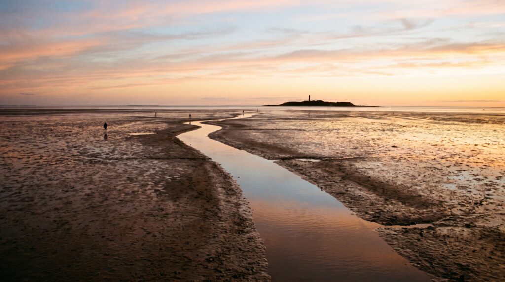
So what is the Wadden Sea, really? It’s a wide belt of mud and sand that the tide covers twice a day, then pulls back to bare the sea floor. It runs about 500 kilometers along the coast of three countries. Per the Common Wadden Sea Secretariat, the Netherlands, Germany, and Denmark share it. The whole thing earned its UNESCO World Heritage listing in 2009, mostly for the birds and the tides.
Where is the Wadden Sea? In the Dutch part, it sits off the north coast, and the five islands are the main draw. This place suits nature lovers, birdwatchers, families, and anyone who’ll trade crowds for quiet.
Now the honest part. It’s flat. The weather flips fast, and the tide sets the clock, not you. Plan around the tide table, pack a windproof layer, and you’ll do fine. You can visit the Wadden Sea and plan real routes. Start with the official VisitWadden site.
Top Things to Do in the Wadden Sea
The top Wadden Sea activities are guided mudflat walking, seal-watching boat trips, birdwatching during migration, and cycling the islands, all shaped by the twice-daily tides.
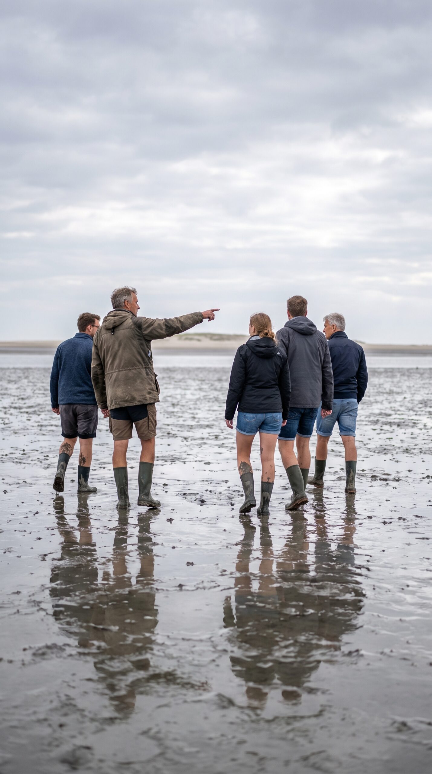
Start with the big one. Wadlopen. It means mudflat walking, and it’s the signature thing to do here. At low tide, the sea pulls back and bares the sea floor. You walk out across it, ankle deep in glossy mud, sometimes wading through knee-high channels. A good mudwalking Wadden Sea trip lasts two to four hours.
One rule matters more than any other. Go with a guide. The tide comes back fast, and hidden channels can cut you off in minutes. People have died out there doing it alone. Book one of the licensed mudflat walking tours and you’re in safe hands. A licensed guide reads the sky, the mud, and the tide table for you.
Not keen on the mud? Take a seal-watching boat trip instead. Boats run from the harbors out to the sandbanks where the tide leaves them dry. Harbour seals and grey seals haul out there to rest, sometimes a few hundred at once. Bring a zoom lens. You’ll spot them lounging in rows, heads tipped up like fat bananas.
Then there are the birds. This Wadden Sea walk crosses one of the busiest bird cafeterias in Europe. The flats feed millions of migratory birds each year on the East Atlantic Flyway, per the Common Wadden Sea Secretariat. Spring and autumn are peak. Godwits, oystercatchers, and brent geese drop in to fuel up. Pack binoculars and you’ll see clouds of them lift off at once.
Want the science first? Stop at the Wadden Sea Centre before you head out. The Wadden Sea Centre walks you through how the tides work, what lives in the mud, and why the whole system matters. It’s a smart first stop, especially with kids. An hour there and the flats make a lot more sense.
Prefer to keep it easy? Just cycle. Every island has flat bike paths that run past dunes, sheep fields, and long empty beaches. Rent a bike at the ferry dock and go. You can pedal for an afternoon, stop for a swim on the North Sea side, and never break a sweat.
Here’s the honest caveat. A Wadden Sea tour lives and dies by the weather. Guides cancel walks and boat trips when the wind kicks up or fog rolls in. The tide table rules everything, so your plans bend around it, not the other way round. Keep a backup day if you can.
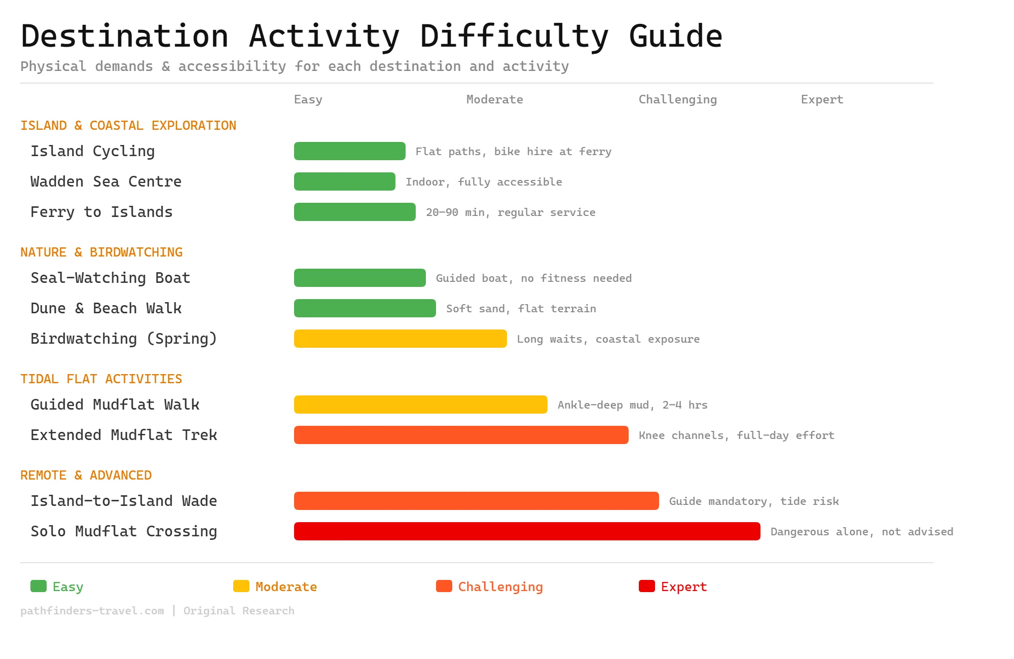
Activity Difficulty Guide
The Wadden Sea spans a wide difficulty range, from flat island cycling and accessible visitor centres to tide-dependent mudflat walks that demand fitness, a guide, and close attention to conditions. Most activities suit families and casual visitors, but extended tidal crossings carry real risk and require licensed guidance. Weather and tides can alter any plan here, so build in flexibility.
The Wadden Islands: Which One to Pick
The Netherlands has five inhabited Wadden islands, from car-friendly Texel, the largest, to tiny car-free Schiermonnikoog, each reached by ferry from a different mainland port.
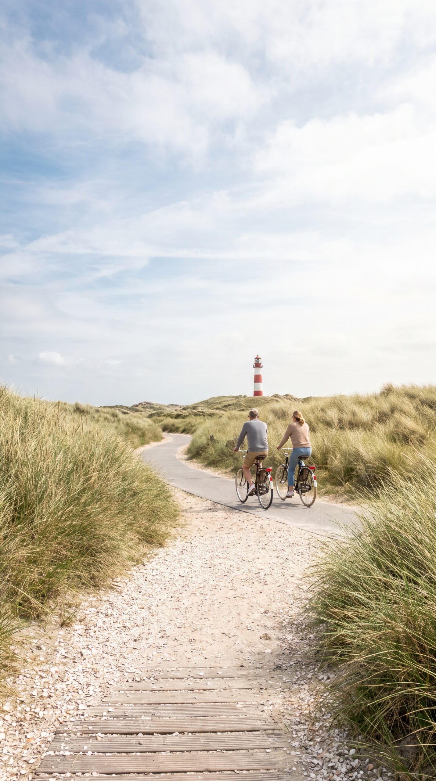
Five islands, five moods. Picking the right one saves you a wasted trip. They all sit off the Wadden Sea coast, but each has its own vibe, and each ferry leaves from a different mainland port.
Texel is the biggest and the easiest. It’s the largest of the Dutch Wadden islands, and the ferry from Den Helder takes about 20 minutes. You can bring a car. It’s got wide beaches, a seal sanctuary, and farm shops selling island cheese and lamb. Good for families who want options.
Vlieland and Schiermonnikoog go the other way. Both are mostly car-free, so you leave the car on the mainland and walk or cycle everywhere. They’re quiet, small, and heavy on dunes and empty sand. Pick these if you want to hear wind and birds instead of traffic.
Terschelling sits in the middle, size wise. It’s known for long beaches and Oerol, a big outdoor theater and music festival that takes over the island each June. Book far ahead for that week.
Ameland is the family pick. Calm beaches, a working lighthouse you can climb, and plenty of bike rentals near the harbor. Easy with kids.
One warning about this stretch of the Wadden Sea area. Ferries book out fast in July and August. If you’re bringing a car to Texel, reserve weeks ahead or you’ll be stuck waiting for a later sailing. Check the ferry crossings to the islands and lock in your slot before you go.
Getting to the Wadden Sea
Reach the Dutch Wadden Sea by train to a mainland ferry port such as Den Helder or Harlingen, then a ferry of 20 to 90 minutes to the islands.
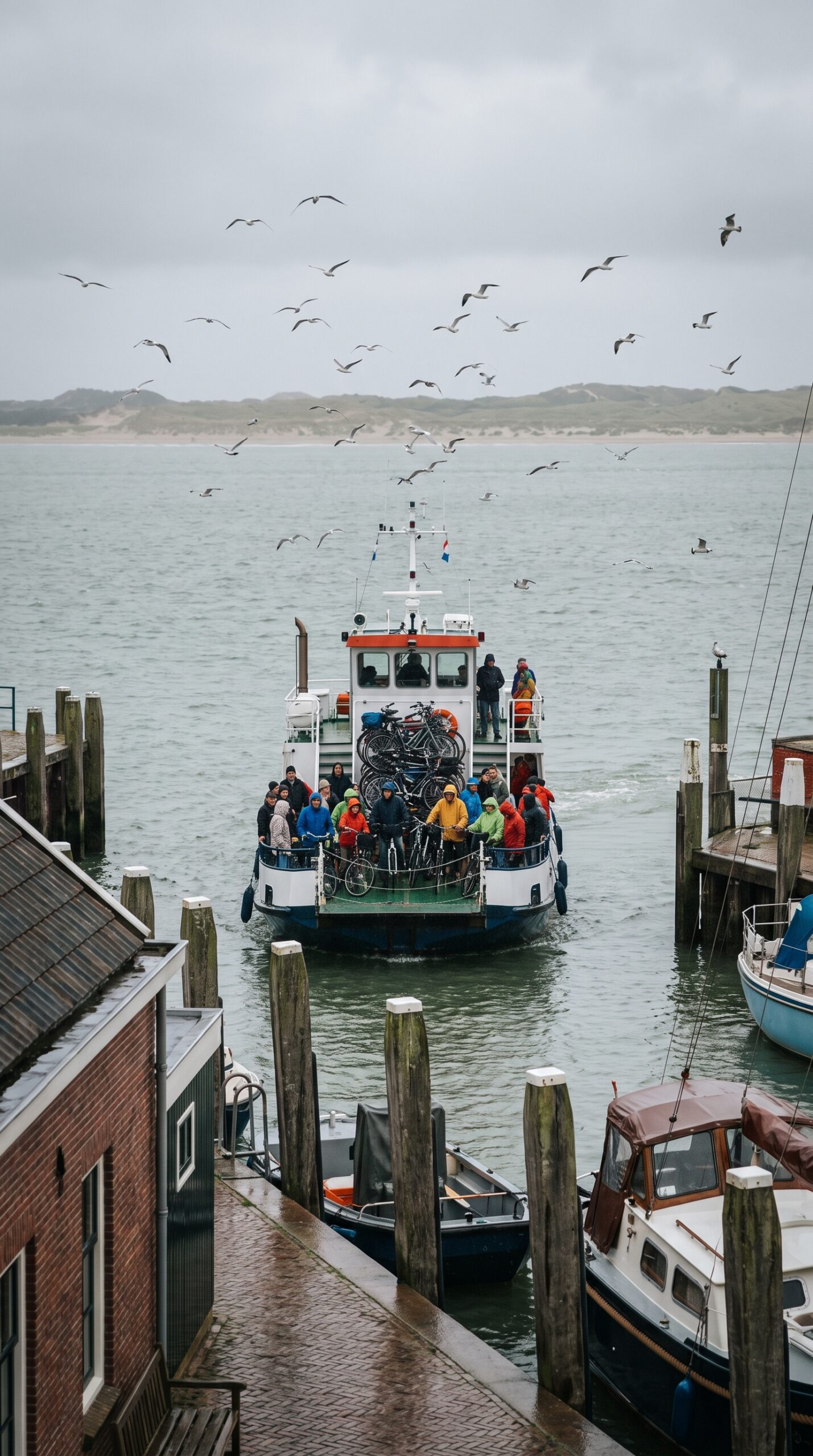
Where is the Wadden Sea, and how do you actually get there? The Dutch Wadden coast runs along the top of the country, from North Holland up through Friesland and Groningen. The islands sit just offshore. Trains and ferries do most of the work.
Most people fly into Amsterdam first. From there, trains run north to the ferry ports. You’ll head to Den Helder for Texel, or Harlingen for Vlieland and Terschelling. Plan the train leg with the NS journey planner, which covers the whole country.
Then you swap to a boat. Ferry crossings run roughly 20 to 90 minutes, depending on which island you pick. Texel is the quick one. The far islands take longer. Check the ferry timetables before you set out, since sailings thin out off season.
Short on time? Amsterdam makes a fine base for a day or two on this Wadden Sea route. You can train up, do a walk or a beach day, and be back by night.
One catch. Some islands limit or ban cars. Check the rules for your island before you drive north, or you’ll pay to park the car and leave it behind.
Day Trips and Nearby Stops
From the Wadden coast you can pair the islands with classic Dutch stops like Volendam, Zaanse Schans, and the reclaimed farmland of Flevoland within a two-hour drive.
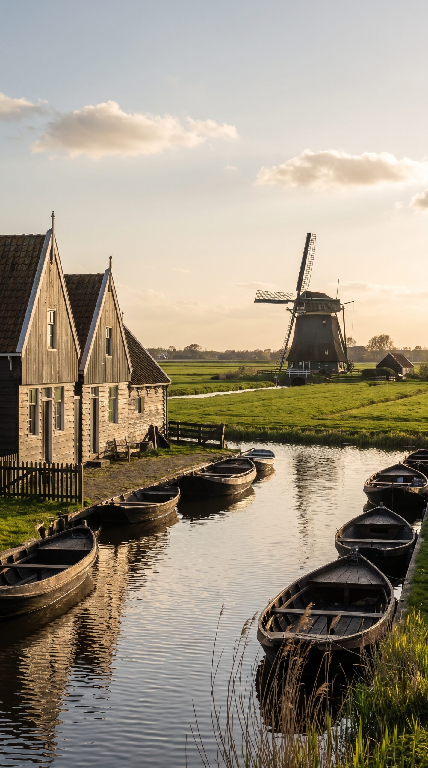
Visiting the Wadden Sea doesn’t have to fill your whole trip. Fold in a stop or two on the way up or back. Most of these sit near Amsterdam, so they slot in easily.
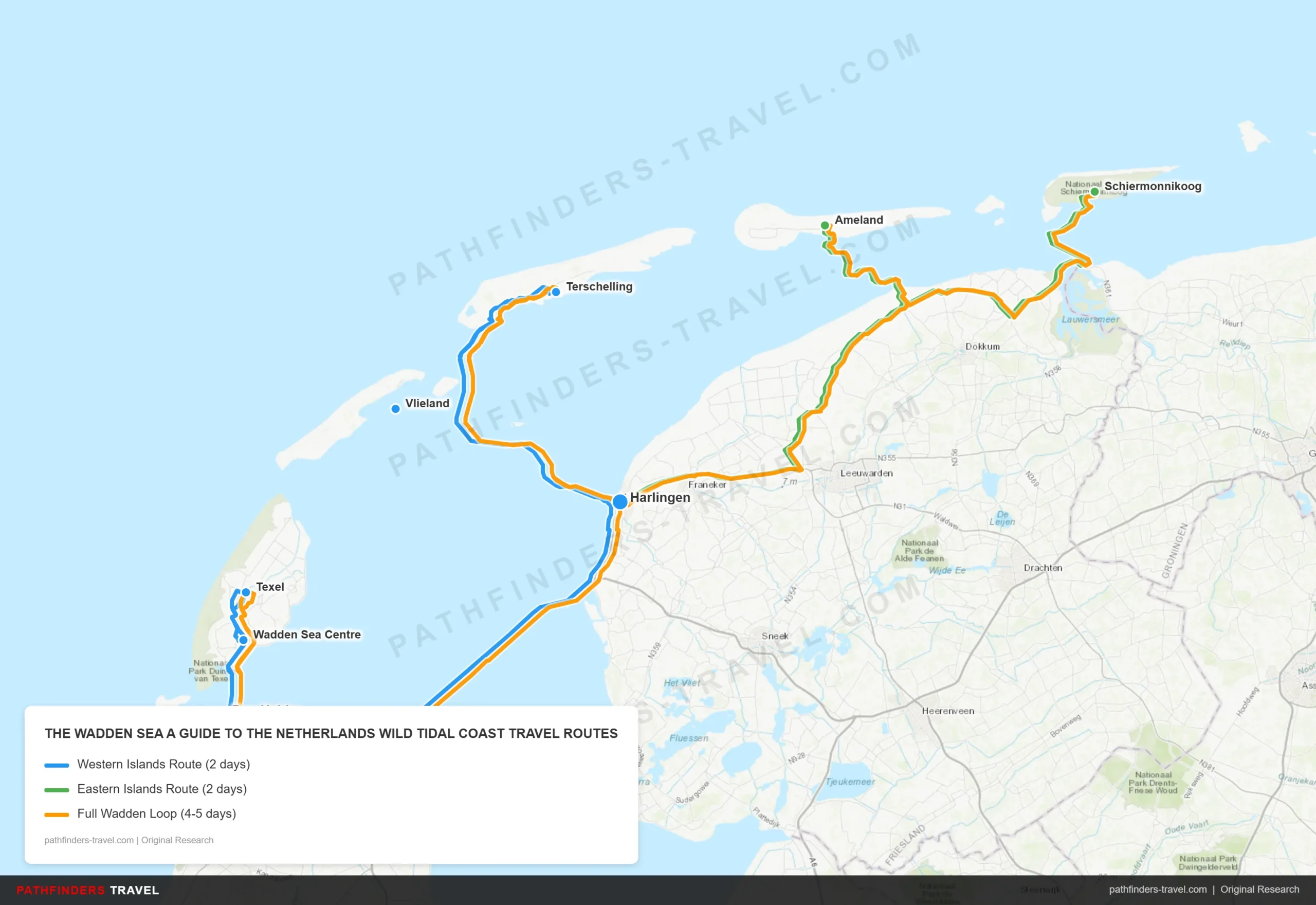
| # | Stop | Highlights | Drive Time |
|---|---|---|---|
| 1 | Den Helder | Main mainland gateway for Texel ferry; naval museum and harbour worth an hour before boarding | Start |
| 2 | Wadden Sea Centre | Essential first stop to understand tides, mudflat ecology, and wildlife; interactive displays great for kids; allow 1 hour | 10 min from Den Helder |
| 3 | Texel | Largest and most accessible island; seal-watching boat trips, cycling dune trails, birdwatching at De Slufter nature reserve, North Sea beaches | 20 min ferry from Den Helder |
| 4 | Vlieland | Car-free island; cycle-only paths through forest and dunes; quietest of the five islands; guided mudflat walks at low tide | 90 min ferry from Texel |
| 5 | Terschelling | Largest eastern island from Harlingen; long beaches, cranberry harvest in autumn, birdwatching during spring migration; lively main village of West-Terschelling | 45 min ferry from Vlieland |
| 6 | Harlingen | Historic harbour town; charming canal architecture; ferry hub for Terschelling and Vlieland; good overnight base on the mainland | 45 min ferry from Terschelling |
| # | Stop | Highlights | Drive Time |
|---|---|---|---|
| 1 | Harlingen | Starting hub for eastern leg; stock up on supplies and check tide tables at the harbour before heading out | Start |
| 2 | Ameland | Guided wadlopen mudflat walks across the Wadden Sea flats; lighthouse at Hollum; grey and harbour seals on nearby sandbanks; horse-drawn tram | 45 min ferry from Holwerd |
| 3 | Holwerd | Small mainland ferry port for Ameland; scenic coastal drive along the Frisian coast connecting to Lauwersoog | 45 min ferry from Ameland |
| 4 | Schiermonnikoog | Smallest and most remote inhabited island; entire island is a national park; no private cars allowed; vast empty beaches and mudflat walking | 45 min ferry from Lauwersoog |
| 5 | Lauwersoog | Easternmost mainland ferry port; national park visitor centre; seal colony visible from harbour at low tide | 45 min ferry from Schiermonnikoog |
| # | Stop | Highlights | Drive Time |
|---|---|---|---|
| 1 | Den Helder | Gateway city; Wadden Sea Centre for orientation; naval museum; catch early morning ferry to Texel | Start |
| 2 | Texel | Full day: seal-watching boat trip, cycling De Slufter, birdwatching; overnight on the island recommended | 20 min ferry |
| 3 | Vlieland | Car-free cycling, forest dunes, guided mudflat walk at low tide; peaceful overnight option | 90 min ferry |
| 4 | Terschelling | West-Terschelling village, long North Sea beach, autumn cranberries, birdwatching; ferry back to Harlingen | 45 min ferry |
| 5 | Harlingen | Mainland overnight stop; historic canals and harbour; restock before eastern leg | 45 min ferry |
| 6 | Ameland | Prime wadlopen destination; guided walks cross open mudflats at low tide; seal sandbanks by boat; lighthouse viewpoint | 45 min ferry from Holwerd |
| 7 | Holwerd | Brief mainland stop; drive east along the Frisian coast to Lauwersoog | 30 min drive |
| 8 | Schiermonnikoog | Remote national park island; car-free, vast beaches, total quiet; best for a slow final day | 45 min ferry from Lauwersoog |
| 9 | Lauwersoog | Return point; seal colony at harbour; national park visitor centre before driving south | 45 min ferry |
Volendam is an old fishing village on the former Zuiderzee, the bay the Dutch later walled off. It’s an easy hop from Amsterdam. Come for the harbor, the smoked eel stands, and the old wooden houses. It gets busy midday, so go early.
Zaanse Schans is the windmill postcard come to life. Working mills still grind mustard and cocoa, and the green wooden houses line a small river. Check hours and tickets on the Zaanse Schans site before you go.
Flevoland ties right into the Wadden water story. It’s the youngest province of the Netherlands, reclaimed from the sea in the 20th century, per Dutch provincial records. Whole towns and farms now sit on ground that used to be seabed. Stand there and the flat, engineered feel of it hits you.
You can see how the Dutch really hold back the water. Two bigger detours pay off. Kinderdijk has a row of 18th-century windmills that once pumped the polders dry, a UNESCO site in its own right. Further south, the Delta Works (Zeeland) is a wall of storm barriers built after the deadly 1953 flood. Plan those with help from Holland.com.
One honest caveat. These spots are spread out. Kinderdijk and the Delta Works sit far south, hours from the Wadden coast. Pick one or two, not all five, or you’ll spend the day in the car.
Best Time to Visit and What to Pack
Planning Tip
The best time to visit the Wadden Sea is May to September for warm mudflat walks and bird migration, though the weather stays cool and windy year-round.

Aim for May through September. That’s when the weather’s mildest and the bird migration peaks. July and August draw the most Wadden Sea tourism, so book beds and ferries early if you come then. May, June, and September stay quieter.
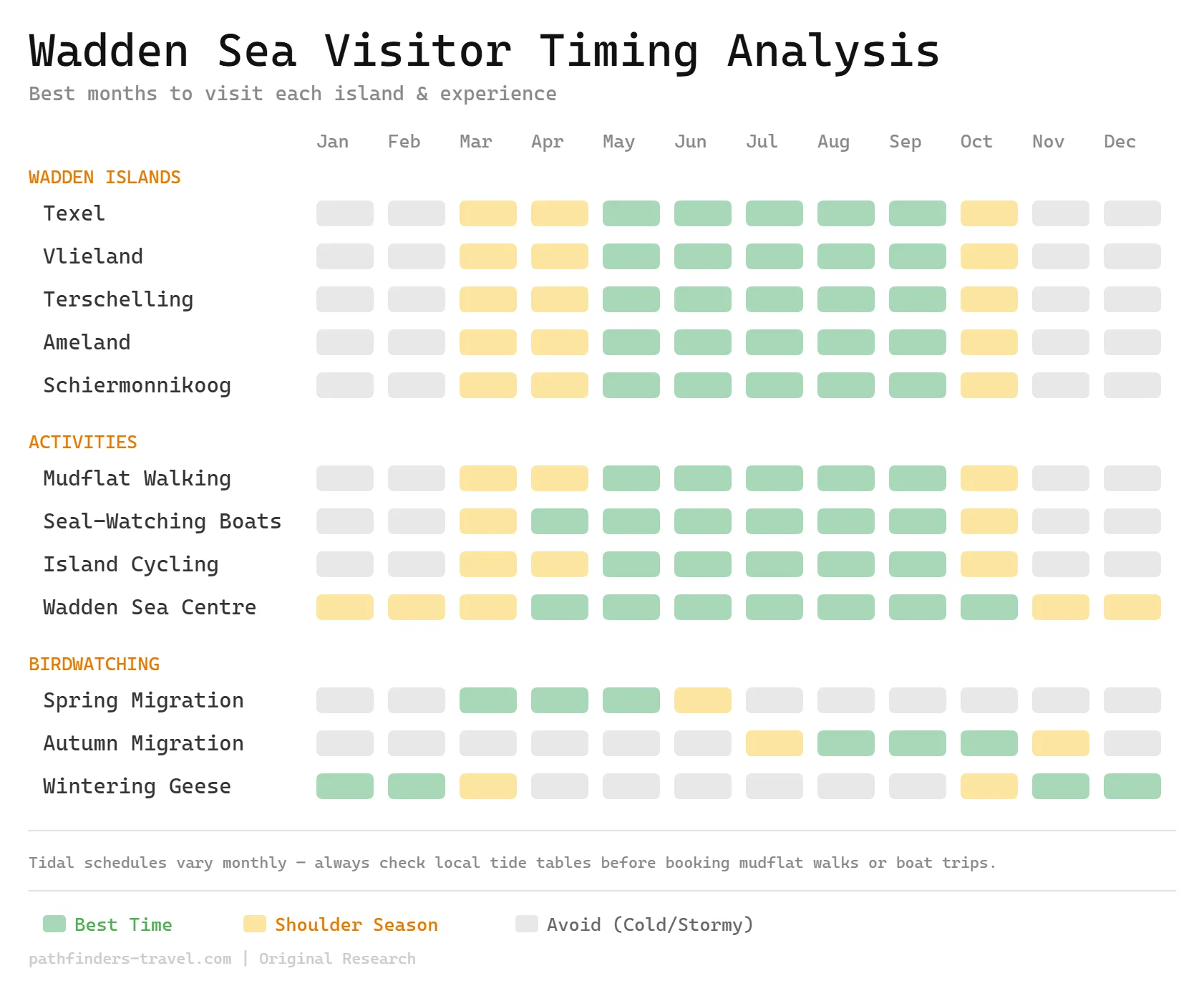
The season matters less than the tide. Mudflat walks only run at low tide, following the twice-daily tidal cycle. So you plan around the water, not the calendar. Before you visit the Wadden Sea, check the tide and water level data for your dates.
Pack for wind and wet. Even a sunny day turns cold when the breeze picks up off the sea. Bring:
- A windproof, waterproof jacket
- Old shoes or trainers you don’t mind ruining in the mud
- Sunscreen and a hat, since there’s no shade out there
- Binoculars for the birds and seals
One last caveat. Can you swim in the Wadden Sea? Not really, not in the open flats. The currents are strong and the returning tide is dangerous. Stick to the marked beaches on the North Sea side of the islands, where it’s safer and watched in summer.
Frequently Asked Questions
Where is the Wadden Sea?
The Wadden Sea runs along the North Sea coast of the Netherlands, Germany, and Denmark. In the Dutch part, it stretches from North Holland up past Friesland and Groningen, with the five Dutch islands sitting just offshore.
Can you swim in the Wadden Sea?
Not in the open flats, since fast currents and returning tides make it risky. Stick to the marked North Sea beaches on the islands, where swimming is safer and supervised in summer.
Why is the Wadden Sea important?
It’s a critical feeding ground for millions of migratory birds on the East Atlantic Flyway. It’s also the largest unbroken system of tidal flats on Earth, which is why it holds UNESCO World Heritage status.
Is the Wadden Sea a UNESCO World Heritage Site?
Yes, the Wadden Sea was inscribed as a UNESCO World Heritage Site in 2009. The listing grew over time to cover the Dutch, German, and Danish parts of the tidal system.
What is mudflat walking in the Wadden Sea?
Mudflat walking, or wadlopen, means hiking across the exposed sea floor at low tide. You must go with a licensed guide, since the tide returns fast and hidden channels are dangerous.