This guide contains affiliate links. As an Amazon Associate we earn from qualifying purchases — at no extra cost to you.
Estimated reading time: 13 minutes
Last updated: July 25, 2026
Table of Contents
- Why Is Pulpit Rock Famous?
- Overview of Pulpit Rock (Preikestolen)
- Getting There: How to Get to Pulpit Rock from Stavanger
- Travel Routes
- The Pulpit Rock Norway Hike
- Activity Difficulty Guide
- Exploring the Lysefjord
- Pulpit Rock Hiking Tips & Resources
- Frequently Asked Questions
Why Is Pulpit Rock Famous?
Pulpit Rock (Preikestolen) is famous as Norway’s most spectacular clifftop viewpoint — a flat, 604-metre rock platform towering over the Lysefjord. More than 300,000 hikers a year make the roughly 8 km, 4–5 hour round-trip to its dramatic, railing-free edge. The trailhead is about a 40–45 minute drive from Stavanger through the Ryfast tunnel (no ferry needed).
You can see this for yourself. Click here to jump to this part of the video.
How This Guide Was Researched
This guide was researched using official tourism board data, government park services, and verified traveler accounts. All prices, hours, and logistics were confirmed at the time of publication. We recommend verifying details with local sources before you travel.
Overview of Pulpit Rock (Preikestolen)
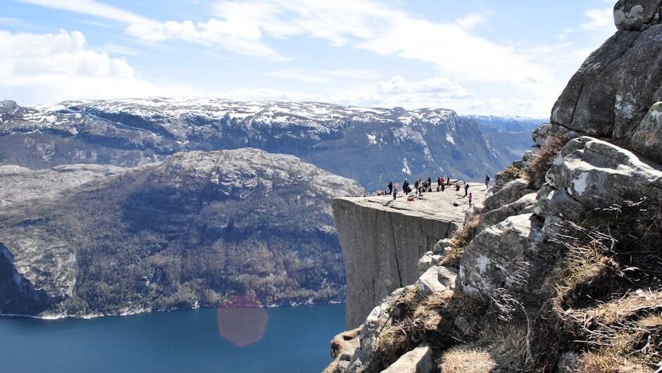
Pulpit Rock (Preikestolen) is a 604-meter-high cliff overlooking the turquoise waters of Lysefjord in southwestern Norway. This flat-topped rock formation provides visitors with impressive wide views that stretch across one of Norway’s most beautiful fjords. On clear days, the vista seems endless, making it a top spot for photographers and nature lovers alike.
What makes this landmark special is its unique geological features. The flat plateau, roughly 25 by 25 meters in size, was formed through glacial erosion thousands of years ago. This perfectly sculpted natural platform draws more than 300,000 hikers annually who come to stand at its edge and take in the beautiful fjord views.
This blog serves as your detailed preikestolen hike guide, covering everything from trail conditions to safety tips. The accessible yet exciting nature of this hike makes it suitable for many fitness levels, which partly explains why it has become one of the most popular natural attractions in all of Norway.
Best Time to Visit
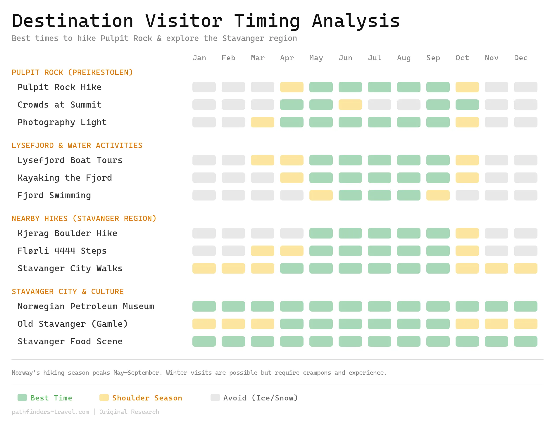
Pulpit Rock is best hiked between May and September when trails are snow-free, daylight hours are long, and all transport services run at full capacity. For the ideal balance of great conditions and smaller crowds, target late May, early June, or the first half of September — peak summer (July–August) brings the most reliable weather but also the heaviest foot traffic at the summit. Winter hiking is possible for experienced hikers equipped with crampons, but most transport options are reduced and trail conditions can be dangerous.
What should I pack for the Pulpit Rock hike?
Pack hiking boots with ankle support, a waterproof jacket, a fleece layer, a daypack with hydration, trekking poles, a sun hat, a headlamp, merino socks, and moleskin. The Pulpit Rock hike is a four-hour round trip over rock and boglike stretches where the weather turns fast, so supportive footwear, layers, and blister protection carry the day.
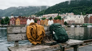
The Pulpit Rock hike kit
A four-hour round-trip climb over rock and bog to the cliff edge.
- Hiking boots with ankle support — steep, rocky, slippery stone steps
- A waterproof jacket — fjord weather shifts fast, even on sunny days
- A fleece layer — conditions change with altitude and wind
- A daypack with hydration — carry 1-2 litres; it’s a 4-5 hour round-trip
- Trekking poles — they save your knees on the steep, rocky descent
- A sun hat — the plateau is fully exposed with no shade
- A headlamp — for the pre-8 a.m. starts that beat the crowds
- Merino wool hiking socks — cushioning and blister defense on the stone steps
- Moleskin blister pads — stick them on before the steep descent
As an Amazon Associate we earn from qualifying purchases.
Getting There: How to Get to Pulpit Rock from Stavanger
Knowing how to get to Pulpit Rock from Stavanger is essential for planning your adventure. Here are your main transportation options to reach the trailhead:
Transportation Options
By Bus:
- The most straightforward option is taking a GoFjords direct bus from Stavanger to the Preikestolen trailhead.
- This route has been simplified since the opening of the Stavanger-Tau tunnel, which eliminated the need for a ferry crossing.
- Buses run regularly during high season (May-September) but have reduced schedules during off-peak months.
By Car:
- Driving takes approximately 40-45 minutes from Stavanger to the Preikestolen parking area.
- The route is well-marked and scenic, with parking costing around 250 NOK per day.
- Arrive early during peak season to secure a parking spot as the lot fills quickly.
By Guided Tour:
- Many companies offer guided tours with transportation included from Stavanger.
- This option provides the benefit of local knowledge and removes any transportation worries.
- Tours can be booked through visitor centers or online in advance.
Travel Tips
To make your journey to the trailhead smooth and stress-free:
- Always check current transportation schedules, especially if traveling outside peak season.
- If public transport schedules don’t align with your plans, local bus no. 100 to Jørpeland followed by a pre-booked taxi-bus is a good backup option.
- During winter months (November-April), guided tours are strongly recommended due to challenging weather and trail conditions.
- Allow extra time for your journey, particularly during summer when tourist traffic can cause delays.
Travel Routes
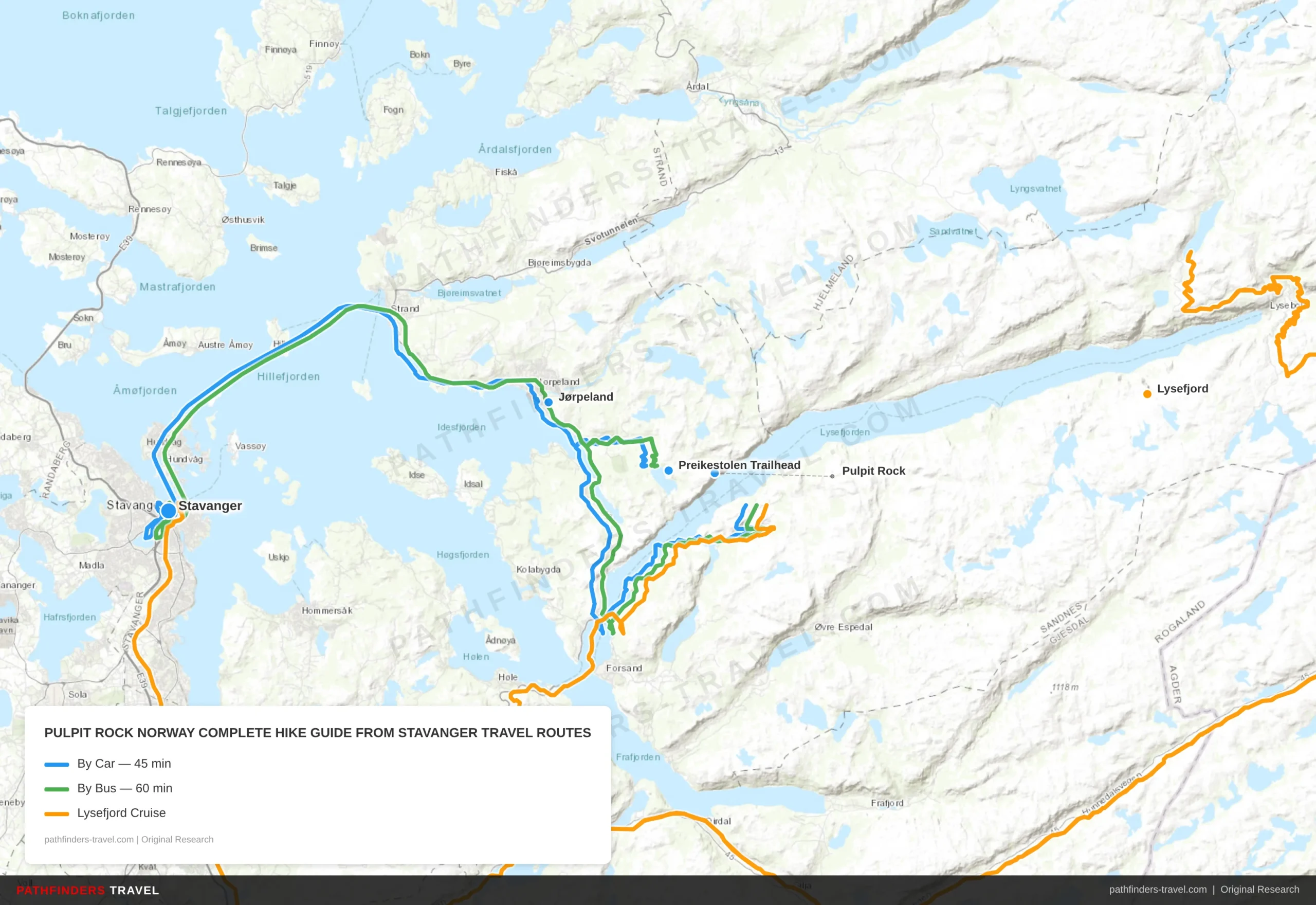
There are three main ways to reach Pulpit Rock from Stavanger — by car, by bus, or via a Lysefjord cruise. Below are the recommended routes with key stops and estimated times.
| # | Stop | Highlights | Drive Time |
|---|---|---|---|
| 1 | Stavanger | Start point — city center parking, fuel up, grab snacks for the hike. Major gateway city with hotels, restaurants, and gear shops. | Start |
| 2 | Jørpeland | Pass through via the Ryfast tunnel — no ferry needed since 2019. Scenic roadside views of the fjord landscape begin here. | 25 min |
| 3 | Preikestolen Trailhead | Preikestolen Mountain Lodge & parking (250 NOK/day). Arrive early in peak season — lot fills by 9am. Trailhead map boards and toilets available. | 20 min |
| 4 | Pulpit Rock | 604m cliff top plateau, 25×25m flat ledge with no railings. Stunning 360° views over Lysefjord. Allow 4–5 hrs round-trip hike (8 km total). | 2–2.5h hike |
| # | Stop | Highlights | Drive Time |
|---|---|---|---|
| 1 | Stavanger | Board GoFjords direct bus from Stavanger bus terminal. Runs regularly May–September; reduced schedule off-peak. Book tickets in advance online. | Start |
| 2 | Jørpeland | Backup option: local bus No. 100 to Jørpeland, then pre-booked taxi-bus to trailhead. Good fallback if direct bus doesn’t align with your schedule. | 30 min |
| 3 | Forsand | Small fjordside village en route. Some bus services stop here briefly — enjoy views of Lysefjord entrance. | 15 min |
| 4 | Preikestolen Trailhead | Bus drops off directly at trailhead. Return buses timed to last hikers down — confirm return schedule before setting off. | 15 min |
| 5 | Pulpit Rock | Norway’s most iconic viewpoint. 604m above Lysefjord — railing-free edge draws 300,000+ hikers annually. Best light: early morning or evening. | 2–2.5h hike |
| # | Stop | Highlights | Drive Time |
|---|---|---|---|
| 1 | Stavanger | Depart from Stavanger harbor. Fjord sightseeing boats run by Rødne Fjord Cruise — book in advance in high season. | Start |
| 2 | Forsand | Gateway village at the mouth of Lysefjord. Some cruises make a brief stop here — views of sheer canyon walls begin to emerge. | 45 min |
| 3 | Lysefjord | 18km-long fjord flanked by 1,000m cliffs. Cruise passes waterfalls, the Flørli wooden staircase, and Hengjane cliff. Wildlife spotting: eagles & seals. | 30 min |
| 4 | Pulpit Rock | View Pulpit Rock from the water — a completely different perspective from 604m below. Spot hikers standing on the edge from the boat deck. | 30 min |
The Pulpit Rock Norway Hike
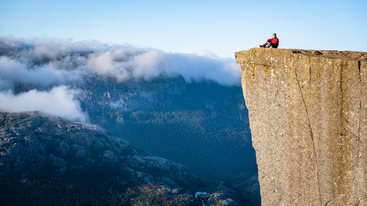
The Pulpit Rock Norway hike is the highlight of many visitors’ trips to this region. Here’s what to expect on the trail:
Trail Details
Distance and Time: The hike is approximately 7.6-8 km (4.7-5 miles) round-trip and typically takes 4-5 hours to complete, including time spent at the summit enjoying the views.
Difficulty: The trail is rated as moderate in difficulty. While not technically challenging, it does include some steep and rocky sections. The path is suitable for reasonably fit adults and children above 6 years of age.
Elevation Gain: You’ll climb approximately 350–500 meters between the trailhead and the top of Pulpit Rock.
Trail Highlights
The path to Preikestolen offers varied terrain and great views along the way:
- The hike begins at Preikestolen Mountain Lodge/BaseCamp with clear signage.
- Early sections take you through beautiful pine forests before emerging onto more open terrain.
- You’ll cross wooden boardwalks over marshy areas and climb well-maintained stone steps in steeper sections.
- Helpful distance markers appear every 500 meters, letting you track your progress.
- Several viewpoints along the trail offer perfect spots for breaks and photos.
- The final approach to Pulpit Rock opens up to reveal great views across Lysefjord.
Packing and Safety
Proper preparation is key to enjoying your hiking experience safely:
Essential Gear:
- Sturdy hiking boots with good ankle support and grip
- Weather-appropriate clothing (layering is recommended as conditions can change)
- Waterproof jacket (even on sunny days, as weather can shift quickly)
- Water bottle (at least 1-2 liters per person)
- Snacks and lunch for energy during the hike
- Sun protection (hat, sunscreen, sunglasses)
- Basic first aid kit
- Fully charged mobile phone
Weather Considerations:
- Always check weather forecasts before starting your hike.
- Fjord weather can change rapidly, be prepared for sudden shifts in conditions.
- Fog can roll in quickly, reducing visibility at the summit.
- During winter and early spring (November-April), the trail may be covered in snow and ice, requiring crampons and hiking poles.
- Be flexible with your hiking plans and be ready to turn back if conditions worsen.
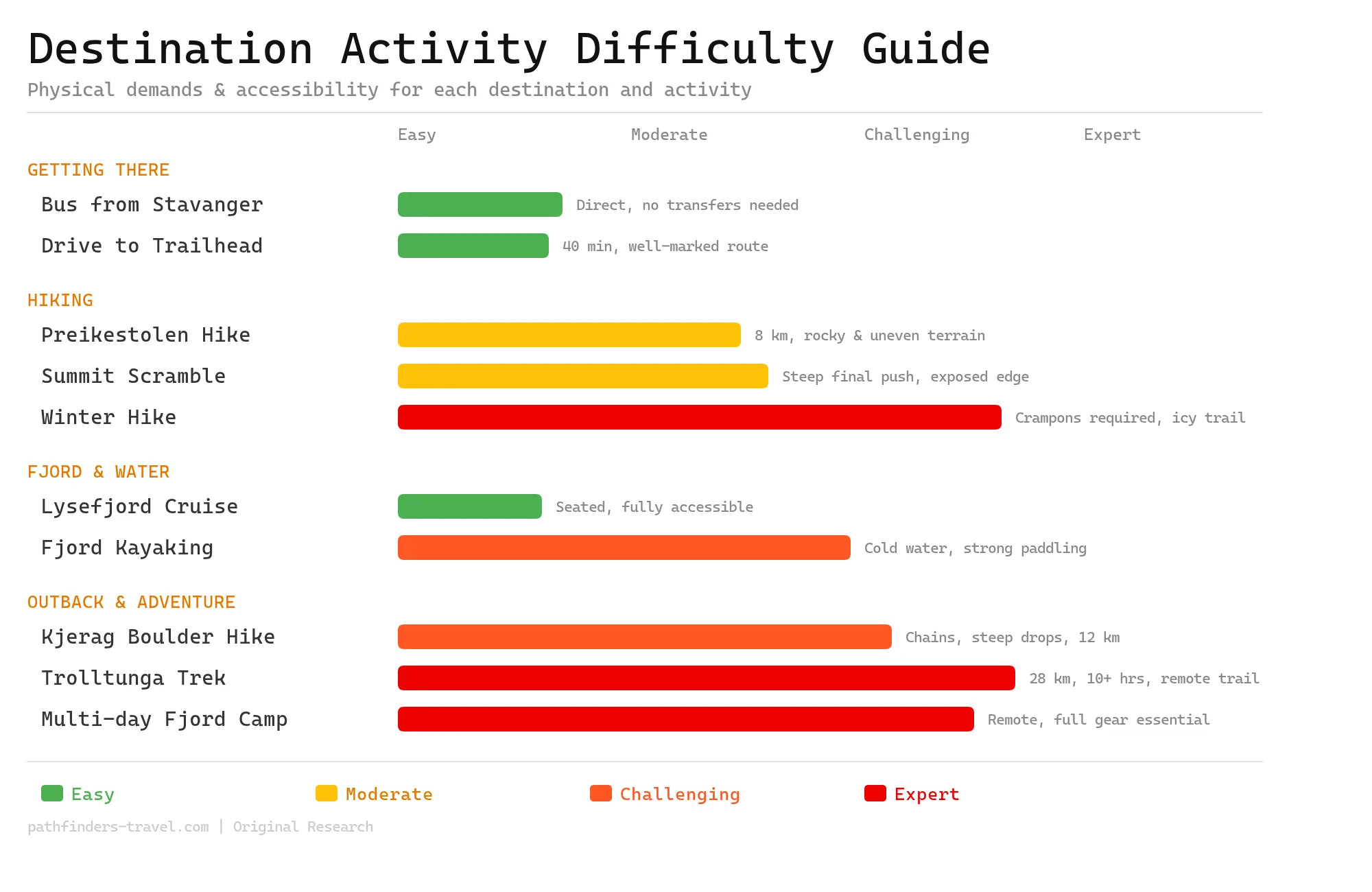
Activity Difficulty Guide
The Pulpit Rock region around Stavanger and Lysefjord offers a wide spectrum of difficulty — from a simple bus ride to the trailhead to multi-day expert-level backcountry treks. The signature Preikestolen hike sits comfortably in the moderate range, making it accessible to most reasonably fit travellers, while nearby adventures like Kjerag and Trolltunga demand serious preparation and experience. Choosing the right activity for your fitness level ensures a safe and rewarding Norwegian fjord experience.
Exploring the Lysefjord
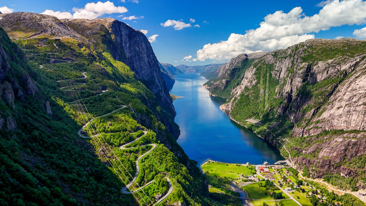
The Lysefjord area offers much more than the Pulpit Rock hike alone. This beautiful fjord, carved by glaciers during the ice age, stretches 42 kilometers inland from the coast near Stavanger and provides numerous opportunities for exploration.
Lysefjord Cruise from Stavanger
A Lysefjord cruise from Stavanger is a perfect complement to your hiking adventure:
- Regular boat tours depart from Stavanger’s harbor, lasting 2-3 hours and showcasing the fjord’s dramatic landscape.
- From the water, you’ll gain a completely different perspective of Pulpit Rock, seeing it towering 604 meters above.
- Cruises typically pass by waterfalls, small settlements, and other natural features only visible from the water.
- Many operators provide informative commentary about the fjord’s geology, history, and wildlife.
Combination Travel Experiences
For a complete Norwegian fjord experience, consider these combination options:
- Hike and Cruise Packages: Several tour companies offer combined experiences where you hike to Pulpit Rock and then return to Stavanger via boat through the fjord.
- Extended Fjord Tours: Longer cruises may include stops at small villages along the Lysefjord, allowing for a deeper exploration of local culture.
- Kayaking Adventures: For the more adventurous, guided kayaking trips on the fjord provide an intimate water-level perspective.
- RIB Boat Safaris: High-speed rigid inflatable boat tours offer an exhilarating way to cover more of the fjord in less time.
The combination of hiking and water-based exploration gives you a complete understanding of this great natural formation. Seeing Pulpit Rock from below on a cruise and then standing atop it after your hike creates a memorable, 360-degree experience of one of Norway’s most iconic landscapes.
Top Picked Activities for Pulpit Rock & Lysefjord
Pulpit Rock Hiking Tips & Resources
Best Times to Visit
The optimal hiking season runs from May through October, when trails are generally free of snow and ice. Here’s what to expect during different periods:
- May-June: Spring conditions with fewer crowds and blooming vegetation, but possibly some remaining snow patches.
- July-August: Peak season with the best weather but also the largest crowds; start early in the morning to avoid the busiest times.
- September-October: Beautiful fall colors and reduced crowds, with cooler temperatures.
- November-April: Winter conditions require special equipment (crampons, poles) and preferably a guide. The experience is magical but significantly more challenging.
General Tips for a Successful Hike
- Start early (before 8:00 AM) to avoid crowds and ensure you have plenty of daylight hours, especially outside of summer.
- Pack more water and snacks than you think you’ll need.
- Wear proper hiking footwear, sneakers are not recommended due to slippery sections.
- Consider a guided tour if you’re new to hiking or want to learn about the area’s geology and history.
- There are no barriers at the edge of Pulpit Rock, stay at least 2-3 meters from the edge if you’re uncomfortable with heights.
- Cell phone coverage is generally good along the trail, but don’t rely on it exclusively for navigation.
- Leave no trace, carry out all trash and stay on marked trails to protect the natural environment.
Resources and Links
To enhance your planning, consider these helpful resources:
- Trail maps and GPS routes are available through apps like Outdooractive and AllTrails.
- Travel itineraries can help you fit the Pulpit Rock hike into a broader Norway adventure.
- Current bus schedules can be found on the GoFjords website or at the Stavanger tourist information center.
- For guided hikes and tours, companies like Outdoorlife Norway and GoFjords offer various packages.
- Budget planning is important as Norway can be expensive, packed lunches and advance bookings help manage costs.
- Fjord tour operators can provide combined hiking and boating experiences.
Frequently Asked Questions About Pulpit Rock
How long is the Pulpit Rock hike?
The Pulpit Rock (Preikestolen) hike is about 8 km (5 miles) round trip with roughly 350–500 metres of climbing, taking most hikers 4–5 hours including breaks and time at the top. Most people spend 30–60 minutes at the summit.
How difficult is the Preikestolen hike?
It is rated moderate. The trail is not technically hard but includes steep, rocky sections and stone steps. Reasonably fit adults and children over about six manage it; wear proper hiking boots, as some sections get slippery.
How do you get to Pulpit Rock from Stavanger?
From Stavanger it is about a 40–45 minute drive to the Preikestolen trailhead via the Ryfast subsea tunnel (no ferry needed); parking costs around 250 NOK per day. In high season, GoFjords buses also run from Stavanger, and guided tours include transport.
When is the best time to hike Pulpit Rock?
The main season is May to October, when the trail is mostly free of snow and ice. July and August have the best weather but the biggest crowds, so start before 8 a.m.; May–June and September–October are quieter. Winter hikes need crampons and ideally a guide.
Is the Pulpit Rock hike worth it?
Yes. Preikestolen is Norway’s most famous hike, ending at a flat cliff 604 metres above the Lysefjord with breathtaking views. It is busy in summer, but the payoff — and the option to also see it from a Lysefjord cruise below — makes it well worth it.