Estimated reading time: 18 minutes
Key Takeaways
- Kunanyi/Mount Wellington is an iconic landmark that towers over Hobart, offering spectacular wide views of the city and its surrounding areas.
- The mountain features dramatic dolerite formations like the Organ Pipes and diverse hiking trails for all skill levels.
- Access options include driving up Pinnacle Road, hiking various trails, or taking the Mt. Wellington Explorer Bus service.
- Wellington Park encompasses over 18,000 hectares of protected natural landscape with numerous recreational opportunities.
- Weather conditions at the summit can change rapidly, so visitors should always check forecasts and dress appropriately before heading up.
Table of Contents
- Introduction
- Spotlight on Mount Wellington (Kunanyi)
- Getting to the Summit: Kunanyi/Mount Wellington Summit
- Exploring Hiking Trails on Mount Wellington
- Wellington Park Hobart Guide
- Best Views of Hobart
- Frequently Asked Questions about Mount Wellington
- Conclusion and Additional Tips
Introduction
Hobart, Tasmania, is a lively capital city that perfectly balances rich colonial history with dramatic natural beauty. Set the mouth of the Derwent River and beneath the towering presence of kunanyi/Mount Wellington, Hobart offers visitors a unique blend of heritage architecture, a lively waterfront district, and easy access to impressive wilderness areas. If you’re also visiting mainland Australia, don’t miss our complete things to do in Sydney travel guide.
The city’s strategic location provides a perfect base for exploring both urban attractions and natural wonders. Colonial-era buildings line the streets of Battery Point and Salamanca, while the harbor buzzes with activity with fishing boats and Antarctic research vessels.
If you’re planning a trip, here are the top things to do in Hobart, Tasmania, including a visit to the iconic Kunanyi. From exploring the mountain’s summit to discovering hidden trails and viewpoints, this guide will help you make the most of your visit to one of Australia’s most engaging destinations.
You can see this for yourself. Watch our cinematic Mount Wellington video in UHD 4K Resolution.
Spotlight on kunanyi/Mount Wellington History and Landscape
Mount Wellington is a defining element of Hobart’s skyline, rising toweringally to 1,271 meters above sea level. This imposing natural landmark is visible from nearly every angle of the city, creating a dramatic backdrop that has shaped Hobart’s identity since its founding. mountain, it represents a powerful connection between the urban environment and the wild Tasmanian landscape.
The mountain holds profound cultural significance for Tasmania’s Aboriginal people, who know it as kunanyi. In recognition of this heritage, the mountain was officially granted dual-name status in 2013, becoming “kunanyi/Mount Wellington.” This naming acknowledges both the European history and the much older Aboriginal connection to this sacred place.
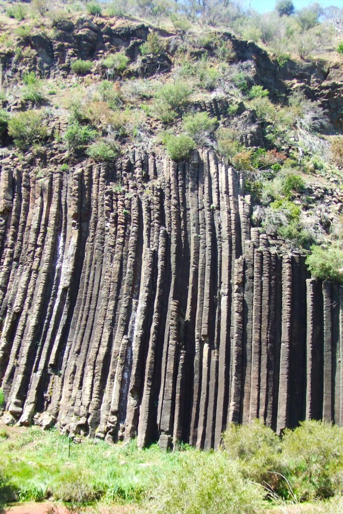
One of the mountain’s most impressive features is the collection of dramatic dolerite columns known as the Organ Pipes. These towering rock formations were created by the cooling and contracting of molten rock approximately 170 million years ago, resulting in the recognizable columnar joints that now dominate the mountain’s eastern face.
For visitors exploring the best views of Hobart, the mountain serves as a central vantage point. From its summit, you can enjoy sweeping panoramas that stretch across the city, the Derwent River estuary, Bruny Island, and on clear days, all the way to the Tasman Peninsula. This 360-degree vista offers perspective on how the landscape has shaped the development of Hobart and its surroundings.
The mountain’s diverse ecosystems support a range of unique flora and fauna, with the environment changing dramatically as you ascend from temperate rainforest at lower elevations to alpine vegetation near the summit. This natural diversity makes Mount Wellington not just a scenic landmark but a valuable ecological reserve right on Hobart’s doorstep.
Getting to the kunanyi/Mount Wellington Summit: Access and Transport Guide
Reaching the kunanyi/Mount Wellington summit is an essential experience for visitors to Hobart, with several access options available depending on your preferences, time constraints, and physical abilities.
Access Options
Driving: The most straightforward way to reach the summit is by car via Pinnacle Road, which winds approximately 21 kilometers from Hobart’s CBD to the top. The drive typically takes about 30 minutes and offers spectacular views along the way. The road is generally open year-round, though it may close temporarily during adverse weather conditions, particularly when snow or ice makes driving hazardous.
The summit area has a designated parking lot with space for approximately 80 vehicles. During peak tourist season (December-February) and on weekends with good weather, this lot can fill quickly, so arriving early is advisable. Road conditions vary seasonally, with winter bringing potential ice and snow, requiring extra caution.
Hiking: If you like an active approach, numerous hiking trails lead to the summit from various starting points. These range from challenging full-day hikes to more moderate routes:
- From The Springs (a popular rest area about halfway up the mountain), the Pinnacle Track offers a moderately challenging 2.5-hour hike to the summit.
- The more difficult Zig Zag Track provides a steeper but more direct route from The Springs.
- For experienced hikers, trails from Fern Tree and other lower points allow for longer, full-day adventures to the top.
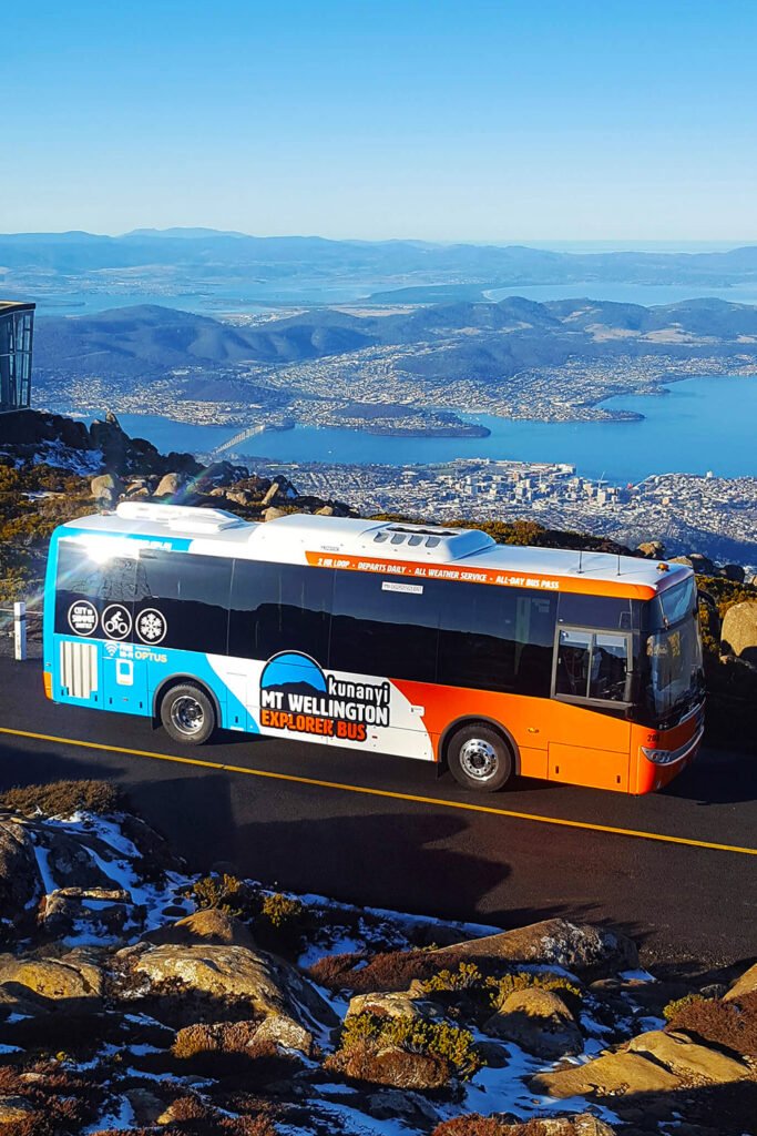
Public Transport: The Mt. Wellington Explorer Bus provides a convenient shuttle service from Hobart to the summit, with departures throughout the day. This hop-on/hop-off service allows visitors to explore various points of interest along the way, including The Springs and several lookout points. The bus operates year-round, weather permitting, and includes informative commentary about the mountain’s history and features.
Practical Tips
Planning Tip
Weather conditions at the summit can be dramatically different from those in Hobart. The mountain creates its own microclimate, with temperatures typically 10-15°C cooler at the top than in the city below. Conditions can change rapidly, with clear skies giving way to thick cloud, rain, or even snow within minutes.
Visitors should always check the latest weather forecasts before heading up and dress in layers, even in summer. Wind-proof and waterproof outer layers are essential, as the summit can experience strong winds exceeding 100 km/h on some days.
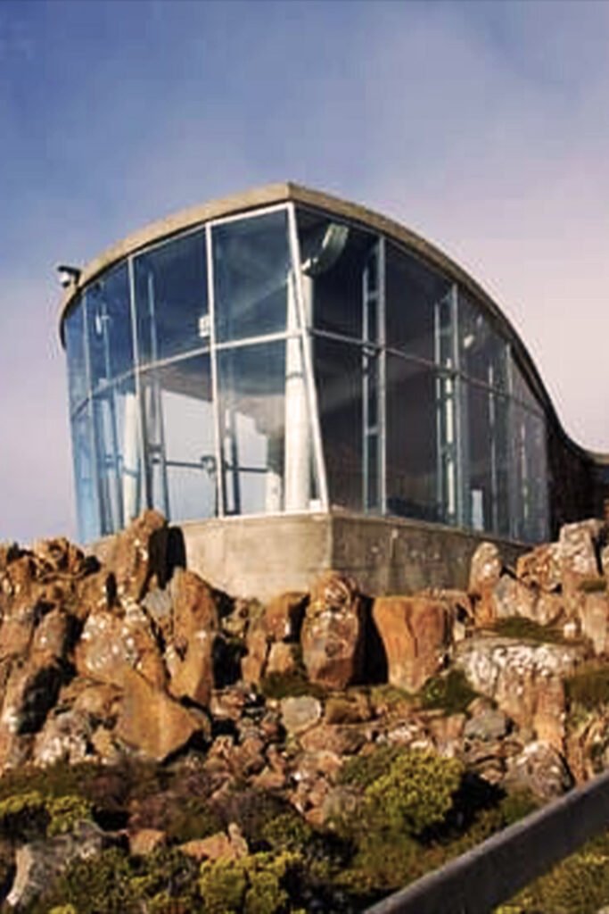
Summit amenities include an enclosed observation shelter that protects from the elements while still offering wide views through large windows. There are also several viewing platforms, interpretive displays about the mountain’s geology and ecology, and basic toilet facilities. No food or drink is available for purchase at the summit, so bringing your own supplies is recommended.
Planning your ascent with the right information make sures the best experiences with things to do in Hobart, Tasmania and Mount Wellington. The summit experience varies greatly depending on weather and season, making each visit unique.
Best Hiking Trails on Mount Wellington | Hobart Walks
The network of hiking trails on Mount Wellington offers some of Tasmania’s most accessible wilderness experiences, with routes catering to all fitness levels and time constraints. These paths showcase the mountain’s diverse ecosystems and provide numerous vantage points for appreciating its natural beauty.
Popular Trails
- Pinnacle Track (Moderate, 3.8 km one way): Starting from The Springs, this well-maintained trail winds upward through changing vegetation zones to reach the summit. The track is well-marked and takes approximately 2.5 hours one way, making it ideal for reasonably fit walkers seeking a great challenge.
- Zig Zag Track (Challenging, 1.9 km one way): This steeper, more direct route to the summit follows the historic bridle path constructed in the 1890s. The trail features numerous switchbacks (hence the name) and offers glimpses of the Organ Pipes along the way. While shorter than the Pinnacle Track, its steeper gradient makes it more physically demanding.
- Organ Pipes Track (Moderate, 1.7 km one way): This spectacular traversing track runs beneath the dramatic dolerite columns of the Organ Pipes. Rather than ascending to the summit, it provides close-up views of these geological formations and wide vistas across Hobart. The track connects with other routes, allowing for various circuit options.
- Sphinx Rock (Easy, 1 km return): Perfect for families or those seeking a shorter walk, this gently graded path leads with The Springs and a natural rock formation with excellent views over Hobart. The 30-minute return journey makes it accessible to most visitors.
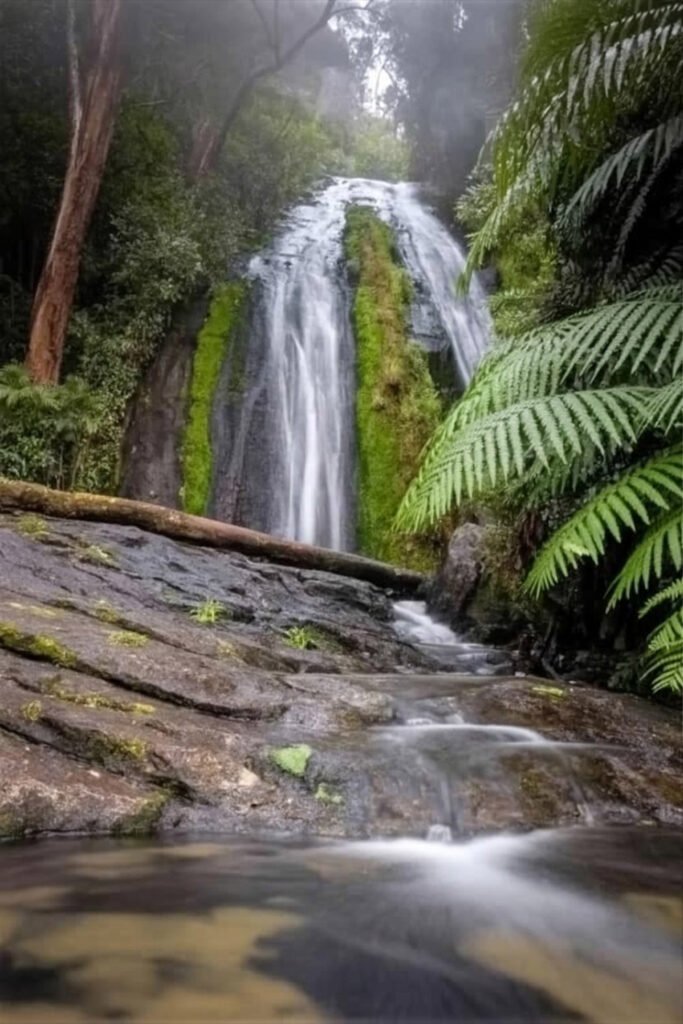
- Silver Falls Track (Easy-Moderate, 2.5 km one way): This scenic trail follows a cascading stream through thick rainforest, passing several small waterfalls before connecting with other tracks. The cool, shaded environment makes it particularly pleasant during warmer months.
Natural Wonders and wide Vistas
What makes these trails really special is how they showcase the mountain’s great ecological diversity. As you ascend, you’ll pass through distinct vegetation zones, from the wet sclerophyll forests of eucalyptus and ferns at lower elevations to the hardy alpine plants near the summit that survive extreme conditions.
The Organ Pipes represent the most dramatic geological feature on the mountain. These massive dolerite columns rise vertically for hundreds of meters, creating an imposing wall visible from throughout Hobart. The Organ Pipes Track offers the closest view of these formations, passing directly beneath their towering presence.
Along many trails, natural lookout points provide views across Hobart and the Derwent Estuary. These vantage points offer opportunities to appreciate how the city nestles between the mountain and the water, with islands dotting the estuary and the Tasman Peninsula visible in the distance on clear days.
Recommended Trail
For visitors seeking a balance of challenge and scenery, the Organ Pipes Track stands out as a particularly great choice. This trail offers close encounters with the mountain’s most recognizable geological feature while providing spectacular views across Hobart without requiring the full ascent to the summit. Combined with a section of the Pinnacle Track, it creates an excellent half-day circuit that showcases the mountain’s diverse landscapes.
Exploring these hiking trails on Mount Wellington make sures a mix of adventure and outstanding vistas. The mountain’s trail network provides opportunities to connect with Tasmania’s natural environment just minutes from the heart of Hobart.
Before setting out on any hike, check the Tasmania Parks & Wildlife visitor information for updated trail conditions and safety tips.
Wellington Park Hobart Guide to Recreation and Nature
Beyond the mountain itself, Wellington Park encompasses a vast protected area of over 18,000 hectares, extending from the outskirts of Hobart to the Derwent Valley and Huon Valley. This expansive reserve serves as both a natural sanctuary and a recreational playground for locals and visitors alike.
Overview and Resources
Wellington Park was established to protect the mountain’s water catchments, preserve its natural and cultural values, and provide for public recreation. The park encompasses diverse landscapes, from thick rainforests and eucalypt woodlands to subalpine heaths and boulder fields near the summit. Similar to a Blue Mountains day trip, Wellington Park offers quick access to wild scenery from a nearby city
The park is managed by the Wellington Park Management Trust, which oversees conservation efforts and recreational facilities. Key visitor nodes within the park include:
- The Springs: Found 720 meters elevation, this historic site serves as the main visitor hub, with toilet facilities, picnic areas, and the starting point for numerous walking tracks.
- Fern Tree: A scenic suburb at the mountain’s base that offers several trailheads and the historic Fern Tree Bower rest area.
- The Chalet: A historic shelter located partway up Pinnacle Road that provides a convenient rest stop.
- The Summit: The pinnacle area featuring an observation shelter, viewing platforms, and interpretive displays.
Navigational Tips
Trail maps are essential for safely exploring Wellington Park. Detailed maps are available online through the Wellington Park website, at the visitor information center in Hobart, and at major entry points to the park. Even for short walks, having a map is recommended as weather conditions can change rapidly, reducing visibility.
Cell phone coverage can be unreliable in parts of the park, so downloading offline maps before your visit is advisable. Major walking tracks are marked with color-coded signs corresponding to their difficulty level, helping visitors choose appropriate routes for their abilities.
The park’s layout accommodates various visitor preferences, from scenic drives along Pinnacle Road to extensive networks of walking tracks. For casual walkers, shorter, well-maintained paths near The Springs and Fern Tree provide accessible options. Avid hikers can tackle longer routes that explore the park’s remote areas or connect multiple tracks for full-day adventures.
Unique Features
Beyond the well-known Organ Pipes and summit views, Wellington Park harbors numerous special features worth exploring:
- Rock climbing areas: The Organ Pipes are a popular destination for climbers, offering numerous routes of varying difficulty on their dolerite columns.
- Mountain biking trails: The park contains designated mountain biking tracks, including the North-South Track and the Glenorchy Mountain Bike Park, catering to riders of different skill levels.
- Waterworks Reserve: Found the park’s eastern boundary, this historic water supply area features scenic reservoirs, picnic facilities, and walking paths.
- Lost World: A dramatic rock formation accessed via a challenging track, offering unique views and a sense of remoteness despite its proximity to Hobart.
- Silver Falls: A scenic cascade surrounded by ferns and mossy rocks, creating a cool microclimate even on warm days.
Gain insights from this Wellington Park Hobart guide on how best to explore its natural beauty. The park’s accessibility and diverse offerings make it suitable for visitors with a range of interests, with nature photography and vigorous outdoor activities or peaceful contemplation in its natural surroundings.
Best Lookouts for Views of Hobart
Hobart is blessed with a dramatic topography that creates numerous vantage points for taking in its scenic beauty. From improved lookouts on Mount Wellington to waterfront perspectives, the city offers some of Tasmania’s most photogenic panoramas.
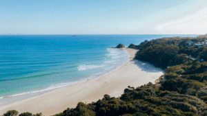
Australia is full of scenic coastal escapes, from Hobart’s views to the beaches up north. If you’re heading further, see our full Byron Bay travel guide for coastal highlights.
Top Lookout Points
Summit Lookout: The ultimate vantage point, located at 1,271 meters above sea level at the very top of kunanyi/Mount Wellington. This all-weather observation shelter provides a 360-degree panorama encompassing Hobart, the Derwent River, Storm Bay, Bruny Island, and on exceptionally clear days, the Tasman Peninsula. Interpretive displays help visitors identify landmarks in the vista before them.
Organ Pipes Lookout: Found the Organ Pipes Track, this viewpoint offers a different perspective from the summit, with the dramatic dolerite columns in the foreground and Hobart spread out below. The slightly lower elevation sometimes places you above the clouds that occasionally obscure the summit, creating magical views.
Sphinx Rock: This family-friendly lookout is easily accessible via a short walk from The Springs. The natural rock formation provides an excellent midway vantage point with less exposure to extreme weather than the summit, making it ideal when conditions at the top are too severe.
The Pinnacle Observation Shelter: Adjacent to the summit, this enclosed structure offers protection from the elements while still providing spectacular views through large windows. Information panels explain the geological and human history of the mountain and the surrounding areas.
Lost World: For those willing to venture off the more popular tracks, this secluded area offers dramatic boulder fields and cliff edges with views toward Collins Cap and the more remote western parts of Wellington Park.
Scenic Views and Timing
The lookout points capture a great diversity of scenery. From most vantages, Hobart’s cityscape nestles between the mountain and the broad Derwent River, with suburbs extending along the water’s edge and up the surrounding hillsides. The Tasman Bridge spans the river, connecting the eastern and western shores, while boats of all sizes get around the harbor.
Beyond the urban area, the views extend to the rural landscapes of the Coal River Valley to the east and the forested ridges of the Wellington Range to the west. On the horizon, Bruny Island rises from the waters of the D’Entrecasteaux Channel, while the rugged silhouette of the Tasman Peninsula marks the eastern extent of the view.
Visiting cultural landmarks in Hobart can be enhanced by understanding how they fit into this broader landscape context visible from the mountain’s viewpoints.
Ideal Times for Photography
For photographers seeking to capture the best views of Hobart, timing is crucial:
- Sunrise: Early morning often brings still conditions and the mountain’s shadow gradually retreating across the city as the sun rises. The golden light illuminates the eastern shore first, creating dramatic contrasts.
- Late afternoon to sunset: The western light bathes the city in a warm glow, with long shadows adding depth to the landscape. As the sun sets behind the western mountains, the city lights begin to twinkle on, creating a magical transition.
- Clear winter days: The crisp, clean air of winter often provides the most far-reaching visibility, sometimes extending beyond 100 kilometers. The occasional dusting of snow on the summit adds another dimension to photographs.
- Fog and cloud effects: Some of the most dramatic images occur when low cloud or fog fills the valley, with only the taller buildings poking through like islands in a white sea.
These points capture the best views of Hobart, enhancing every visitor’s itinerary. Mount Wellington’s various lookouts offer perspectives that help connect the urban environment with its natural surroundings.
Frequently Asked Questions about kunanyi/Mount Wellington
What is the best season to visit Kunanyi/Mount Wellington for hiking and views?
The mountain can be visited year-round, but conditions and hiking experiences vary by season. Summer (December, February) has the most stable weather for trails and panoramas, while winter (June, August) brings snow and icy roads. Autumn and spring offer milder conditions with fewer visitors. Always check the forecast before setting out. For tropical contrasts, see our Whitsunday Islands travel guide for tropical contrasts, best enjoyed in winter when Tasmania is cool.
How do you reach the kunanyi/Mount Wellington summit from Hobart city?
You can drive via Pinnacle Road, a 30-minute trip from Hobart’s city center, though closures may occur during snow or ice. The Mt. Wellington Explorer Bus is another option, with hop-on/hop-off stops. Hikers can also ascend from The Springs, Fern Tree, or other trailheads.
Are there easy hiking trails on Kunanyi/Mount Wellington for beginners and families?
Yes, several shorter trails are well-suited for beginners. Sphinx Rock is a quick 30-minute return walk with views, and the Silver Falls Track provides a shaded forest route with small cascades. The Organ Pipes Track is moderate but manageable for most visitors.
What facilities and services are available at the kunanyi/Mount Wellington summit?
The summit area has an enclosed observation shelter with wide windows, multiple viewing platforms, interpretive panels on geology and ecology, and basic toilets. There are no shops or cafés, so visitors should bring water, snacks, and warm clothing.
Where can you find the best views of Hobart from Kunanyi/Mount Wellington lookouts?
The summit lookout at 1,271 meters provides the most expansive panorama over Hobart city, the Derwent River, Bruny Island, and the Tasman Peninsula. Other excellent spots include the Organ Pipes Lookout and Sphinx Rock, each offering different vantage points.
Conclusion
Kunanyi/Mount Wellington and the wider Wellington Park remain central to Hobart’s identity, offering accessible wilderness and sweeping views only minutes from the city. Hike one of the mountain’s varied tracks, or pause at lookouts like Sphinx Rock or the Organ Pipes, the experience highlights Tasmania’s blend of urban life and dramatic landscapes.
For a smooth visit, check weather forecasts, prepare with layered clothing, and carry your own supplies. Early mornings or weekdays often provide quieter conditions on both the summit road and popular trails. Outdoor enthusiasts will also find opportunities for climbing, biking, or exploring hidden spots within the park.
Pairing a visit to kunanyi with Hobart’s cultural highlights, such as Salamanca Market or MONA, creates a balanced itinerary that combines nature and heritage. Travelers planning broader Tasmanian journeys can also connect their experience here with nearby regions like the Huon Valley or the Tasman Peninsula, each offering distinct scenery and history. If you’re heading north, our Cairns travel guide covers the Great Barrier Reef and Daintree Rainforest.
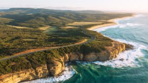
For more travel inspiration, see the Great Ocean Road itinerary guide for another Australian drive rich in natural beauty.
You can see more cinematic journeys like this. Visit the Wonders of the World series on my YouTube channel, Pathfinders Travel, where every destination is captured in beautiful UHD 4K resolution