Estimated reading time: 17 minutes
Last updated: March 2026
Planning Tip
Key Takeaways Smith Rock is the birthplace of American sport climbing and offers 1,800+ climbing routes Misery Ridge Trail is the most popular hike with beautiful wide views Day-use parking fee is $5 per vehicle; annual Oregon State Parks pass available Skull Hollow Campground and Bivouac walk-in sites provide camping options Best visited spring and fall; summer temperatures often exceed 95°F Located 30 minutes from Bend, 2.5 hours from Portland
Table of Contents
- Welcome to Smith Rock State Park
- Top Trails and Climbing Routes
- Where to Stay Near Smith Rock
- Getting to Smith Rock State Park
- Fees and Passes
- Day Trips from Smith Rock
- When to Visit and What to Bring
- Frequently Asked Questions
Welcome to Smith Rock State Park
Smith Rock State Park in central Oregon became the birthplace of American sport climbing in 1986 and now attracts over 700,000 annual visitors to its dramatic rhyolite canyon.
How This Guide Was Researched
This guide was compiled from travel documentaries, verified tourism sources, and community traveler feedback. Prices and operational details were confirmed at the time of writing. We recommend checking official sources for the latest information before your trip.
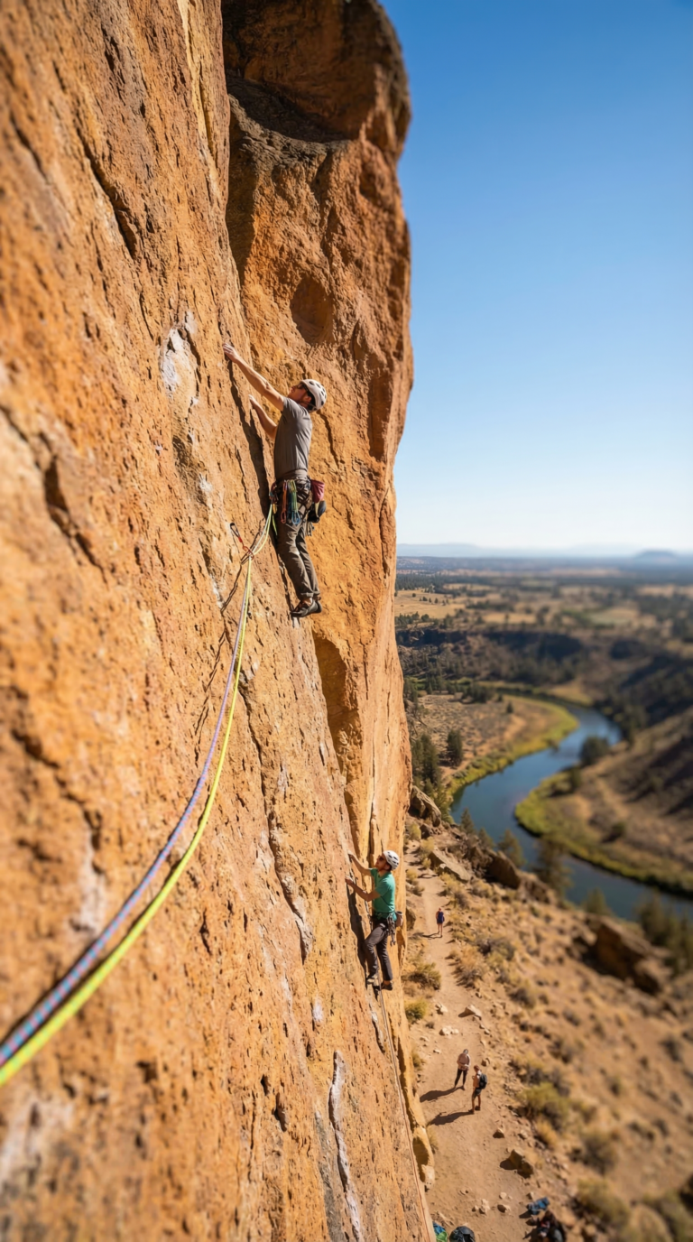
Smith Rock State Park changed American climbing forever in 1986. That year, French climber Jean-Baptiste Tribout freed the route “To Bolt or Not to Be,” establishing the first 5.14a in North America. The sport climbing revolution started here. Climbers drilled bolts into these orange cliffs. They practiced moves on ropes. They pushed grades higher than anyone thought possible on American rock.
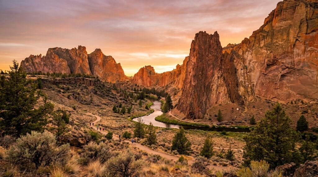
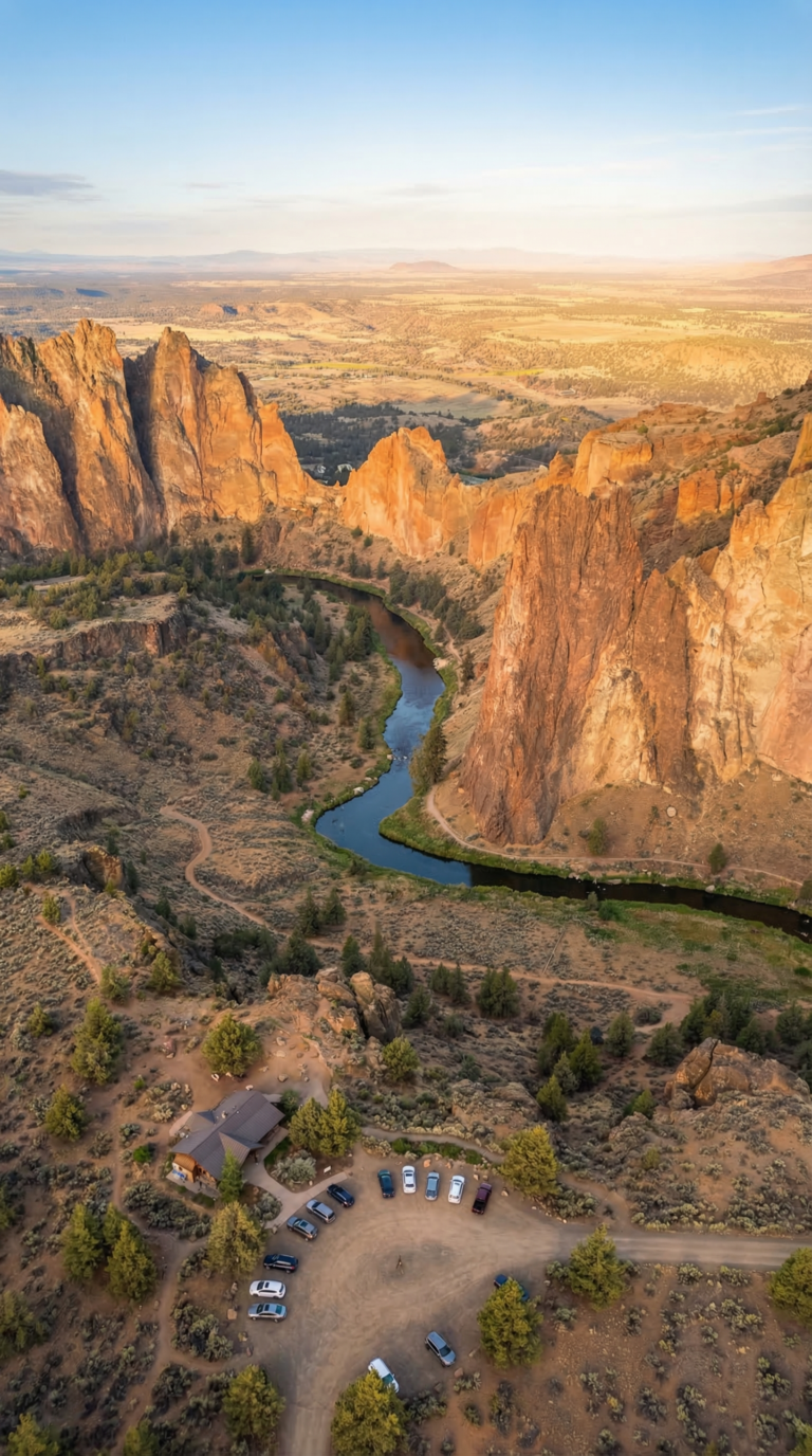
The park sits 30 minutes northeast of Bend near the town of Terrebonne. Rhyolite towers rise 600 feet above the Crooked River. The river carved this canyon through volcanic rock over millions of years. High desert surrounds everything, juniper trees, sagebrush, rattlesnakes, golden eagles.
Climbers come for 1,800 routes. Monkey Face, a 350-foot spire shaped like a primate skull, is the park’s most famous formation. Casual hikers walk the River Trail in sneakers. Serious trekkers tackle Misery Ridge, a steep loop with 800 feet of elevation gain. Photographers shoot sunrise over the Cascade peaks. According to the Official Oregon State Parks website, the park recorded 725,000 visits in 2024, a 15% increase from pre-pandemic levels.
You don’t need climbing gear to enjoy Smith Rock State Park Oregon. The trails deliver. The views deliver. The light at golden hour turns the cliffs into glowing embers.
Top Trails and Climbing Routes
Smith Rock offers over 1,800 climbing routes ranging from 5.5 to 5.14d difficulty, plus seven major hiking trails including the 3.7-mile Misery Ridge Loop with 800 feet of elevation gain.
Smith Rock State Park delivers trails for every fitness level. Easy riverside strolls. Brutal ridge climbs. Everything between.
The Misery Ridge Trail earns its name. This 3.7-mile loop punishes you with 800 vertical feet of switchbacks carved into near-vertical canyon walls. Your quads will scream. But the payoff? Unfiltered views of the entire canyon system, the Cascade peaks floating on the western horizon, and climbers dangling from routes just feet away from the trail. According to Smith Rock State Park Official Trails data, this loop sees over 200,000 hikers annually. Start early. The exposed ridge bakes by mid-morning.
The River Trail offers the opposite experience. Flat. Shaded in spots. Just 2 miles along the Crooked River’s edge. Families with toddlers handle this one fine. Photographers camp here at sunrise when the water mirrors the orange tuff walls in perfect stillness. Zero elevation gain means you can focus on the rock formations instead of your heart rate.
Other smith rock state park trails worth your time: The Summit Trail branches off Misery Ridge for advanced hikers willing to scramble. The Canyon Trail creates a moderate loop option when combined with River Trail segments. Connector paths let you build custom routes using the park’s trail map, grab one at the welcome booth or download the PDF before you arrive.
Smith Rock climbing history runs deep. In 1986, climber Alan Watts bolted the first sport routes here, launching American sport climbing into a new era. Today the park holds over 1,800 established routes documented in the Smith Rock Climbing Routes on theCrag database. Grades span from beginner-friendly 5.5 slabs to desperate 5.14d test pieces that shut down professionals.
The climbing breaks into distinct styles. Sport climbing dominates, bolted routes on the orange rhyolite tuff walls where you clip quickdraws as you ascend. Traditional crack climbing lives in the darker basalt columns, requiring gear placements in natural features. Bouldering areas scatter around the park’s base for rope-free problems. Multi-pitch routes stretch hundreds of feet, demanding full-day commitments. Spring and fall deliver prime climbing temps. Summer mornings work before the rock turns into a griddle. Winter? Only the committed show up.
Monkey Face dominates every smith rock state park photo you’ve ever seen. This 350-foot spire genuinely resembles a primate’s profile when viewed from certain angles. Two eye sockets. A protruding snout. Climbers treat it as a pilgrimage, the routes range with moderate scrambles and technical nightmares. Non-climbers hike close enough for photos from the Misery Ridge trail. The formation appears on every Oregon climbing bucket list.
Smith rock state park geology tells a violent story. The orange and red walls? Welded rhyolite tuff, volcanic ash that fused under intense heat roughly 30 million years ago. The darker vertical columns? Basalt from later lava flows. This contrast creates the park’s signature striped appearance. Erosion by the Crooked River carved the canyon over millions of years, exposing these layers in cross-section. You’re hiking through a geological textbook.
Photography opportunities explode everywhere. The overlook near the main parking area gives you the classic wide-angle canyon shot without hiking. Misery Ridge’s summit offers 360-degree compositions. The River Trail at sunrise or sunset catches the tuff walls glowing orange-pink while the water reflects everything in doubled saturation. Bring a polarizing filter for the river shots. Bring water for the ridge shots, you’ll be up there longer than planned.
Wildlife sightings happen if you pay attention. Golden eagles and prairie falcons nest on the cliff faces, watch for them riding thermals above the canyon. Mule deer browse the sagebrush flats at dawn and dusk. River otters occasionally appear in the Crooked River, though they’re shy. Spring brings wildflower blooms across the high desert scrub, lupine, balsamroot, phlox painting the brown landscape in temporary color bursts.
Where to Stay Near Smith Rock
Planning Tip
Skull Hollow Campground offers 18 primitive sites 2 miles from Smith Rock for $8-21 per night, while the park’s Bivouac Area provides walk-in camping for $5-8 per person.
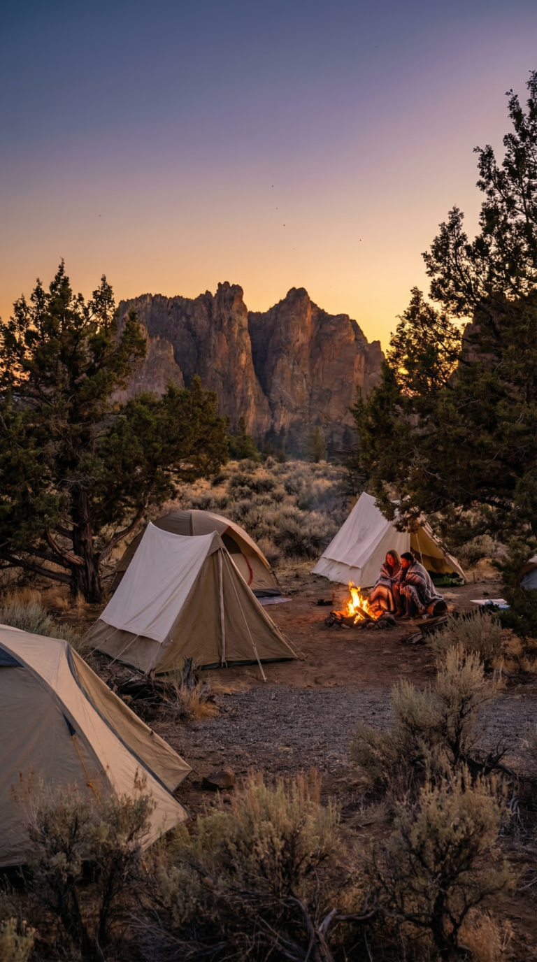
Skull Hollow Campground sits about 2 miles from the park entrance on a high desert plateau. You get 18 primitive tent sites with vault toilets and zero running water. Views stretch across the Crooked River Canyon to Smith Rock’s towers. Deschutes County manages the campground. Reservations are mandatory during peak season, spring and fall weekends book out weeks ahead. Sites cost $8-21 depending on the season and first-served. Basic facilities mean pit toilets and nothing else. Fees run $5-8 per person according to the Oregon State Parks camping reservation portal. The climbing community camps here constantly. Expect to hear gear clinking at 5 a.m.
Smith Rock has no RV hookups. Zero. RV campers need to aim for Terrebonne or Redmond. Full-service RV parks with water and electric sit 10-15 minutes away. Check availability early if you’re rolling in during climbing season.
Hotels cluster in three zones. Terrebonne offers the closest beds but limited choices. Redmond sits 15 minutes out with standard chain hotels. Bend gives you the full spread, budget motels to boutique lodges, but you’ll drive 30 minutes each way.
All camping near Smith Rock is primitive. Bring every drop of water you’ll need. Desert nights drop 40 degrees from daytime highs. Pack layers. Haul out your trash. No exceptions.
Getting to Smith Rock State Park
Smith Rock State Park is located at 9241 NE Crooked River Drive, Terrebonne, OR 97760, approximately 26 miles northeast of Bend (30 minutes) and 140 miles from Portland (2.5 hours).
The park sits in central Oregon’s high desert. From Bend, take US-97 north to Terrebonne, then follow signs east on B Avenue and NE Wilcox Avenue to the park entrance. The drive takes 30 minutes on clear roads.
From Portland, you’ll drive 2.5 to 3 hours. Take US-26 east through Mount Hood National Forest, then US-97 south to Terrebonne. Check the Official Oregon State Parks directions page for Smith Rock for road closures during winter.
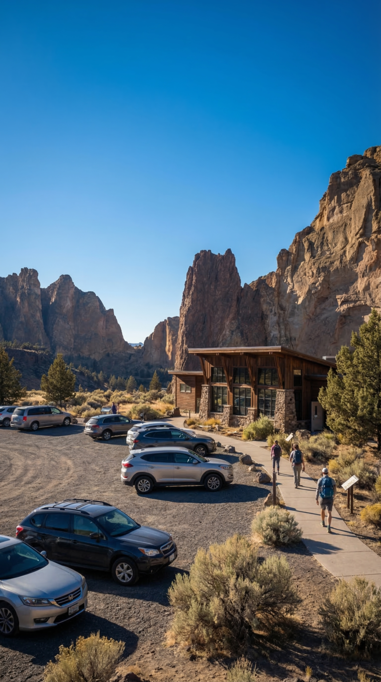
You can drive through Smith Rock on a scenic loop road. Free parking at the amphitheater area lets you snap photos without paying the day-use fee. The main Welcome Center parking lot requires a fee and fills up fast on weekends. Arrive before 9 AM or visit on weekdays. Overflow lots open during peak times. The bivy campground has limited parking for registered campers only.
Use this Google Maps link to Smith Rock State Park Welcome Center for turn-by-turn navigation.
Fees and Passes
Smith Rock State Park charges a $5 day-use parking fee per vehicle, while an annual Oregon State Parks pass costs $30 and covers all state park day-use areas.
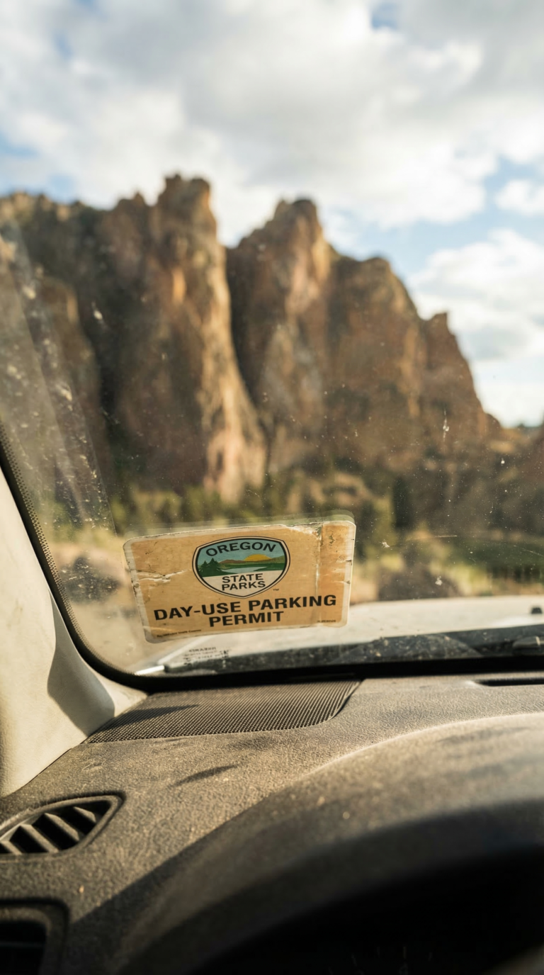
You’ll pay at self-service stations near the Welcome Center parking area. Cash or card both work. The machines are straightforward, no fussing with exact change.
The annual pass makes sense if you’re hitting multiple Oregon parks or planning repeat visits. $30 gets you 12 months of access to every state park day-use area. Do the math: six visits and you’ve broken even.
Walk-ins and cyclists don’t pay. Neither do drivers who cruise the scenic loop road without parking. According to the Official Oregon State Parks fee schedule and pass purchase page, the fee only applies when you leave your vehicle in a designated lot.
Camping fees run separately. The Bivouac Area costs $5-8 per person per night. Skull Hollow Campground ranges from $8-21 per site depending on amenities and season.
No timed entry. No advance reservations for day visits. Just show up, pay the parking fee, and go.
Day Trips from Smith Rock
Bend sits just 26 miles from Smith Rock and serves as central Oregon’s outdoor hub, while Crater Lake National Park (130 miles south) and Mount Hood (120 miles northwest) make excellent full-day excursions.
Bend sits 30 minutes west. The town runs on outdoor recreation and craft beer. Kayak the Deschutes River. Browse the High Desert Museum’s exhibits on regional ecology. Hit a dozen breweries downtown. Bend works as your base camp for central Oregon.
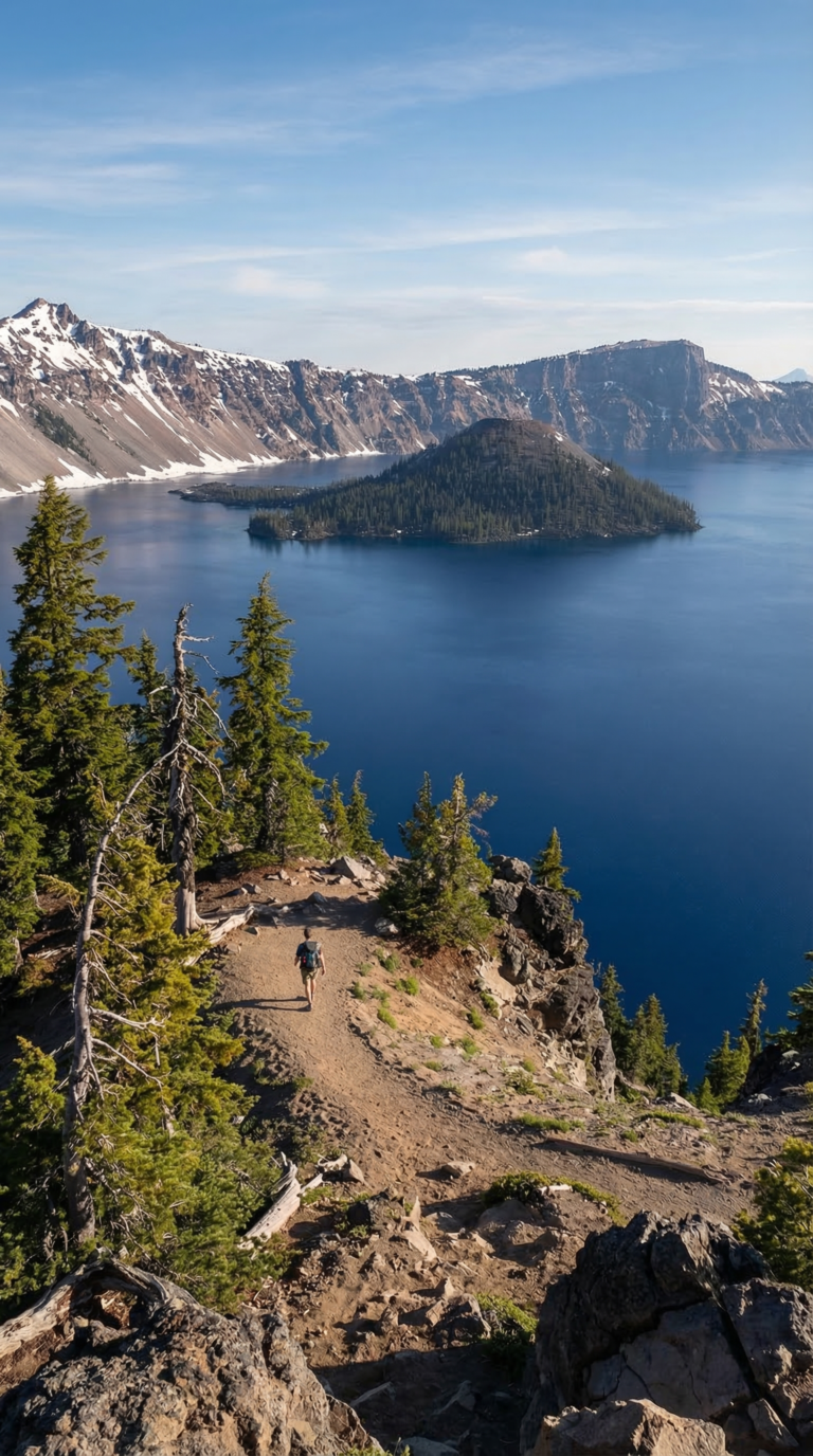
Crater Lake National Park lies 130 miles south, about 2.5 hours by car. Oregon’s only national park holds the deepest lake in the United States at 1,943 feet. The water glows an impossible sapphire blue. Crater Lake National Park opens fully May through October when Rim Drive clears of snow. You can drive the 33-mile loop around the caldera rim.
Mount Hood National Forest spreads across 120 miles northwest. Oregon’s highest peak tops out at 11,249 feet. Timberline Lodge sits at 6,000 feet elevation. The forest offers year-round hiking and scenic drives through old-growth Douglas fir.
Silver Falls State Park sits 2.5 hours northwest. The Trail of Ten Falls passes ten waterfalls in 7.2 miles. You walk behind several of them. The landscape shifts completely from Smith Rock’s high desert to temperate rainforest.
Sparks Lake reflects Mount Bachelor 40 minutes west of Bend. The shallow alpine lake works perfectly for kayaking and stand-up paddleboarding. Newberry National Volcanic Monument sprawls 45 minutes south of Visit Bend, obsidian flows, lava tubes, and two crater lakes. Sisters, a Western-themed town, sits 45 minutes away with Cascade Mountain access.
When to Visit and What to Bring
Smith Rock’s best weather occurs April-May and September-October with temperatures of 60-75°F, while summer highs often exceed 95°F and winter brings occasional snow closures.
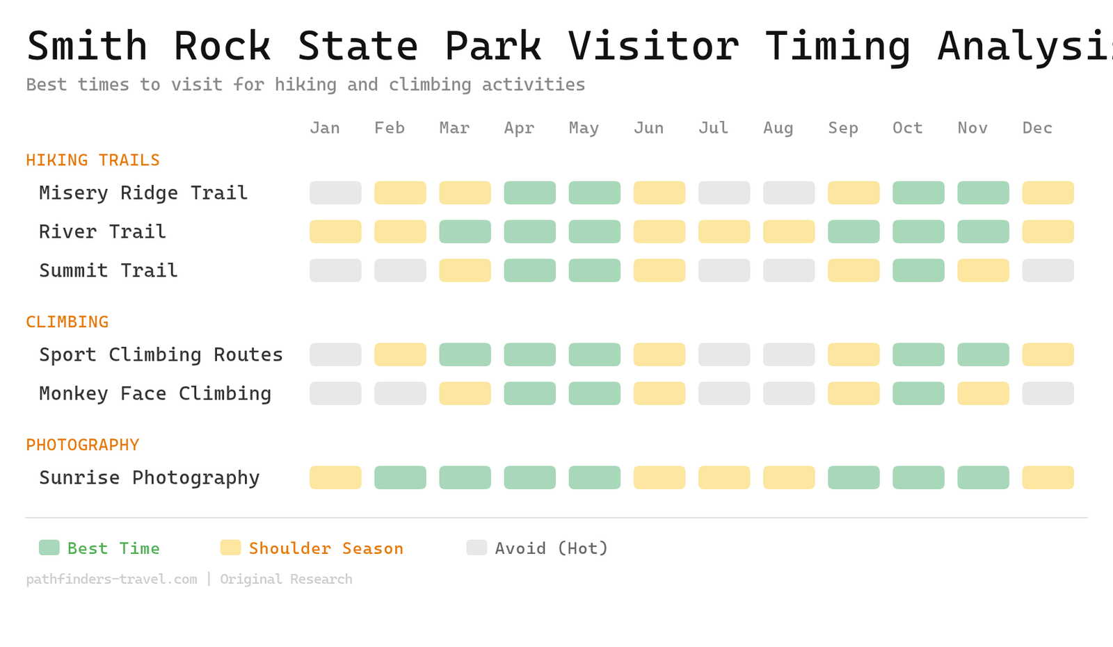
Spring and fall deliver ideal conditions. April through May and September through October hit that sweet spot: 60-75°F, manageable crowds, and comfortable hiking without the summer furnace. Wildflowers bloom in spring. Fall brings crisp mornings.
Summer is brutal. June through August pushes 90-100°F regularly. The high desert climate here means zero shade on most trails. Start your hike by 7am or wait until evening. Bring double the water you think you need. According to the NOAA weather forecast, central Oregon’s high desert receives just 12 inches of rain annually, so expect bone-dry conditions all summer.
Winter can surprise you. December through February drops to 30-45°F during the day. Snow and ice make Misery Ridge dangerous. Check the Smith Rock State Park live webcams before driving out. Temperature swings of 30-40°F between day and night happen year-round.
Pack at least 2 liters of water per person for Misery Ridge. Bring a hat, sunscreen rated SPF 30 or higher, and sunglasses. Sturdy hiking shoes are non-negotiable. Layer your clothing. Throw in trail snacks and a paper map.
The park opens dawn to dusk daily. The Welcome Center runs 9am-4pm most days, but hours shift seasonally. Dogs are allowed on leash. Carry water for them too. Hot pavement in summer will burn their paws.
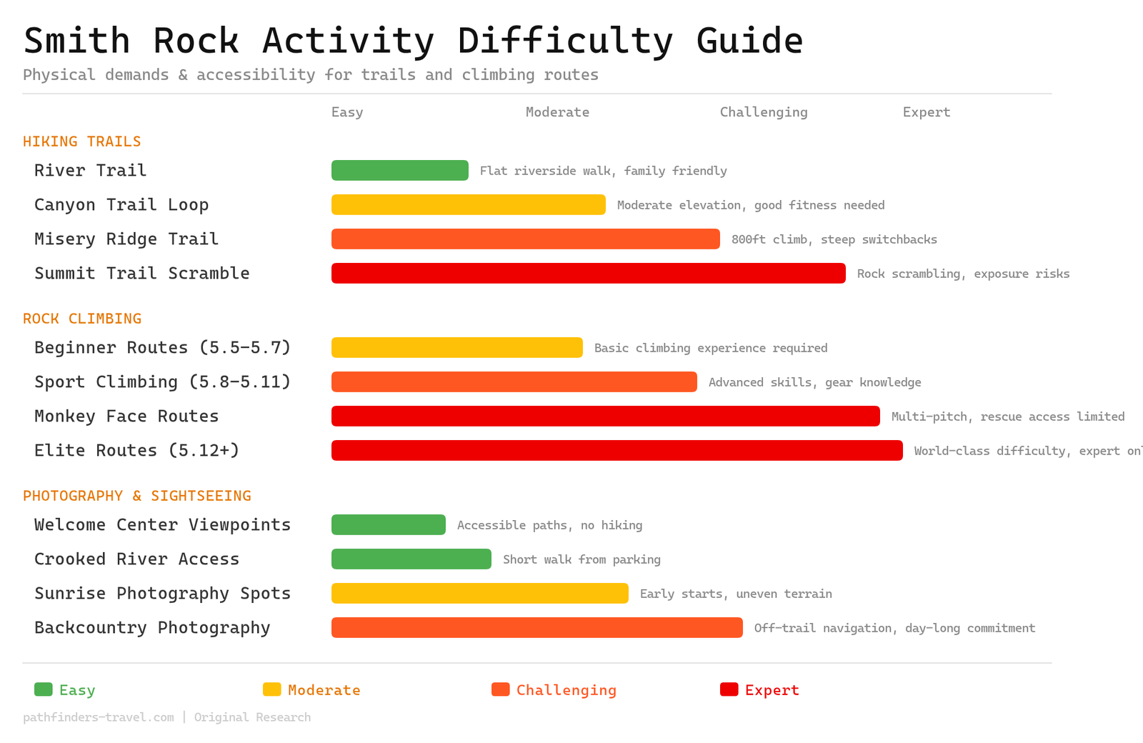
Activity Difficulty Guide
Smith Rock State Park offers extraordinary diversity from wheelchair-accessible river walks to world-class 5.14 climbing routes. The park’s unique volcanic terrain creates challenges ranging from gentle family strolls to life-threatening multi-pitch ascents that require rescue helicopter access.
Frequently Asked Questions
Common questions about visiting Smith Rock State Park, with climbing routes and hiking difficulty and park logistics.
What is Smith Rock State Park famous for?
Smith Rock is internationally recognized as the birthplace of American sport climbing, where the sport was pioneered in 1986. The park features over 1,800 climbing routes on dramatic rhyolite tuff and basalt formations rising 600+ feet above the Crooked River. Beyond climbing, it’s famous for the iconic Monkey Face rock formation, challenging hiking trails, and beautiful high desert scenery that attracts photographers from around the world. Climbers from Japan, Germany, and France make pilgrimages here. The park’s reputation extends far beyond Oregon.
Can you drive through Smith Rock State Park?
Yes, you can drive through Smith Rock on a scenic loop road that offers views of the rock formations. According to visitor reports, you can drive through and stop briefly at the amphitheater area for free to take photos without paying the parking fee. However, to access the Welcome Center parking area and trailheads, you’ll need to pay the $5 day-use fee. The drive-through option works if you’re short on time or just want a quick photo stop.
Is Smith Rock a hard hike?
Smith Rock offers trails ranging from easy to strenuous, so difficulty depends on which route you choose. The River Trail is an easy, mostly flat 2-mile walk suitable for families and casual hikers. Misery Ridge Trail is the most challenging option with 800 feet of elevation gain over steep switchbacks. It’s strenuous but doable for anyone in moderate physical condition. The trail gets its name from the challenging climb, but the wide views from the top make the effort worthwhile. Most people complete Misery Ridge in 2, 3 hours.
Are dogs allowed at Smith Rock State Park?
Yes, dogs are allowed throughout Smith Rock State Park but must be kept on leash at all times. Be prepared to carry water for your dog, especially in summer when temperatures exceed 90°F and there’s little shade. The trails can be rocky and steep (particularly Misery Ridge), so consider your dog’s fitness level and paw protection. Clean up after your pet and pack out all waste. The park provides waste bags at trailheads, but bring extras.
What are the best hikes at Smith Rock State Park?
Misery Ridge Loop (3.7 miles, strenuous) is the most popular trail, offering the best wide views of the canyon and close-up views of climbers. River Trail (2 miles, easy) is perfect for families and provides beautiful reflections of the rock formations in the Crooked River. Canyon Trail (moderate) can be combined with other trails for a custom loop experience. For the best experience, start with the River Trail to warm up, then tackle Misery Ridge if you’re feeling ambitious. Early morning light makes for the best photos on either route.