Estimated reading time: 13 minutes
Last updated: March 2026
Key Takeaways
Table of Contents
- find the Columbia River Gorge
- Top Attractions & Things to Do
- Where to Stay in the Columbia River Gorge
- Getting There & Getting Around
- Day Trips from the Columbia River Gorge
- Practical Information for Visiting
- Frequently Asked Questions
find the Columbia River Gorge
How This Guide Was Researched
This guide was compiled from travel documentaries, verified tourism sources, and community traveler feedback. Prices and operational details were confirmed at the time of writing. We recommend checking official sources for the latest information before your trip.

Multnomah Falls drops 620 feet down a basalt cliff in two tiers. Water crashes over the upper drop, then hits a rock ledge before plunging again. The historic Benson Bridge spans the gap between tiers. This is Oregon’s tallest waterfall and the most-visited natural site in the Pacific Northwest. Over two million people show up every year.
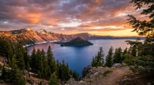
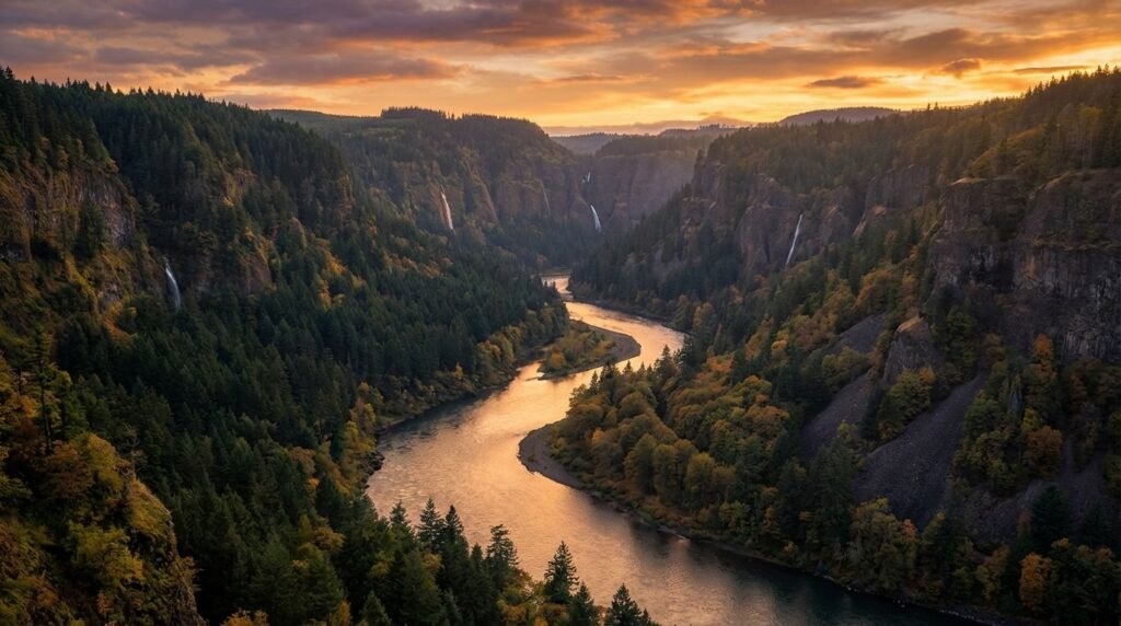
The falls sit inside the Columbia River Gorge National Scenic Area, an 80-mile canyon the Columbia River carved through the Cascade Range. The gorge forms the border between Oregon and Washington. Canyon walls climb over 4,000 feet above the river. That elevation change creates microclimates. The western end gets rain and moss. The eastern end turns dry and brown.
Portland sits 30 to 40 minutes west. You can leave the city after breakfast and stand at the base of a waterfall before lunch. The Official U.S. Forest Service Columbia River Gorge National Scenic Area website lists over 90 waterfalls in the gorge. Some require a five-mile hike. Others sit 50 feet from the parking lot. The Historic Columbia River Highway threads through the western section, passing viewpoints and trailheads.
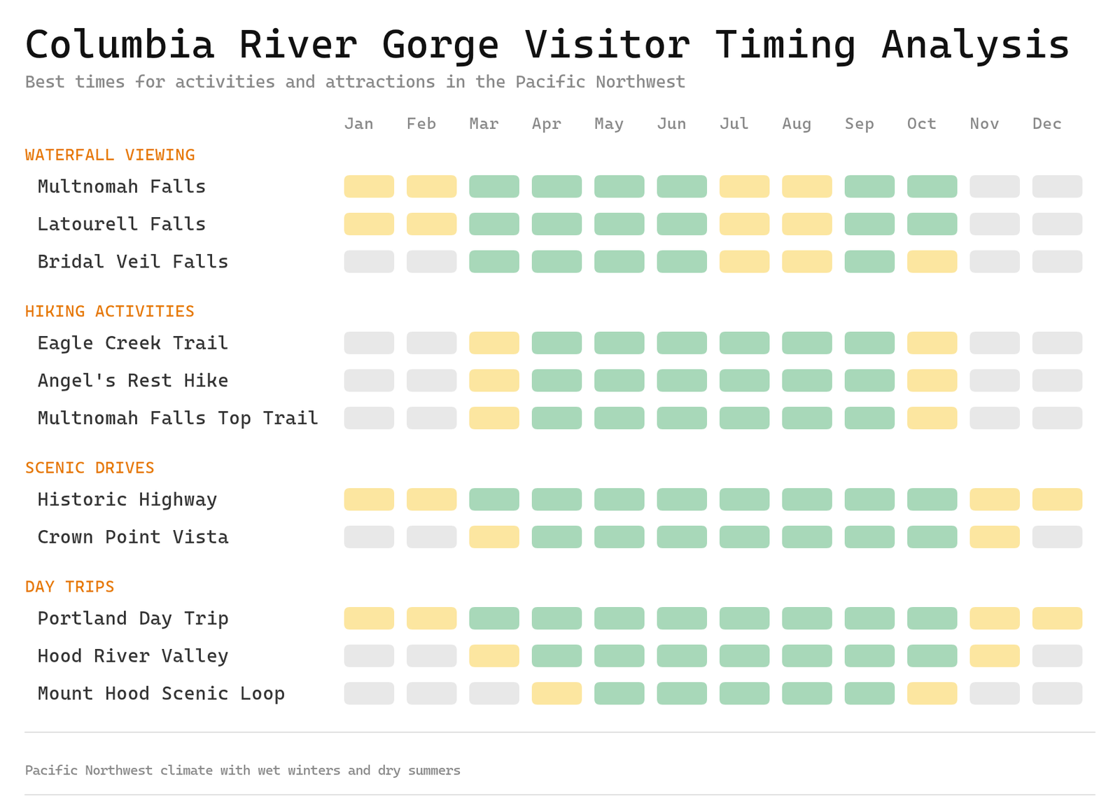
People visit year-round. Spring brings high water flows. Summer fills the trails. Fall colors peak in October. Winter ice coats the cliffs. The gorge works for day trips or multi-day stays.
Top Attractions & Things to Do
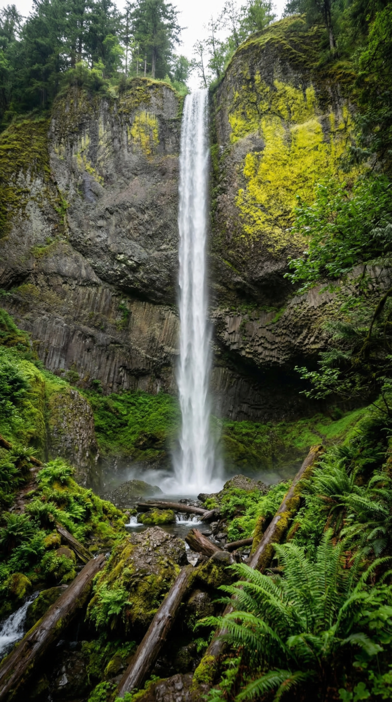
Multnomah Falls drops 620 feet in two tiers. It’s the tallest waterfall in Oregon and the second-tallest year-round waterfall in the United States. The lower tier plunges 542 feet. The upper tier adds another 69 feet. Between them sits Benson Bridge, a stone arch built in 1914 that gives you a face-level view of the cascade’s midsection. Spray hits you even in summer.
Planning Tip
You need a timed-entry permit during peak season (May through September). The Multnomah Falls Timed Use Permit on Recreation.gov costs $2 per vehicle. Slots open 14 days in advance at 7:00 AM Pacific. They sell out in minutes on weekends. Arrive early if you want parking, the lot fills by 8:00 AM even with reservations. Winter months (October through April) require no permit.
The Multnomah Falls hike to the top switchbacks 1.2 miles up 750 feet of elevation gain. It’s paved but steep. Most people turn around at Benson Bridge, which sits 0.2 miles from the parking lot. The full trail takes 90 minutes round-trip if you’re moving. At the top, you stand at the waterfall’s lip and look down the Gorge toward Portland.
Multnomah Falls Lodge anchors the base of the falls. Built in 1925, the stone building houses a restaurant serving breakfast and lunch, a gift shop, and a Forest Service information desk. The architecture mimics alpine chalets. You can grab coffee and a pastry without a permit, the lodge sits outside the ticketed zone.
Latourell Falls plunges 249 feet over a cliff of columnar basalt, hexagonal rock columns that look like a giant’s pipe organ. Park in the pullout on the Historic Columbia River Highway and walk 100 yards to the viewing platform. No permit needed. The basalt formations here are some of the most photogenic in the Gorge. A 2.4-mile loop trail circles behind the falls if you want to get wet.
The Historic Columbia River Highway State Trail – USDA Forest Service connects Latourell to Bridal Veil Falls and beyond. This was America’s first scenic highway, engineered between 1913 and 1922 with stone guardrails and arched bridges. The road winds through the waterfall corridor, hitting 90-plus cascades in 75 miles. Sections of the original highway are now car-free trails. You can bike or walk them.
Bridal Veil Falls drops 120 feet in two stages. The trail is 0.6 miles round-trip, mostly flat, wheelchair-accessible to the overlook. Wahkeena Falls sits two miles east of Multnomah. It’s 242 feet tall and connects to Multnomah via the Wahkeena-Multnomah Loop, a 5.4-mile trail that links both waterfalls through forested switchbacks. Horsetail Falls drops 176 feet straight onto the highway shoulder. You can walk behind it via the Ponytail Falls trail, a 0.8-mile loop that tunnels through rock.
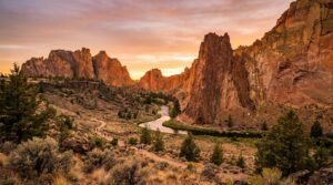
Eagle Creek Trail ranks among the best Columbia River Gorge hikes. It follows a canyon 13 miles one-way, passing Punchbowl Falls and Tunnel Falls (where the trail burrows behind a 100-foot cascade). The first two miles are easy. After that, it gets narrow with cliff exposure. Dog Mountain climbs 2,800 feet in 3.5 miles to wildflower meadows. Go in May when balsamroot blooms cover the slopes. Angels Rest is a 4.8-mile round-trip with 1,500 feet of gain to a rocky summit overlooking the Gorge.
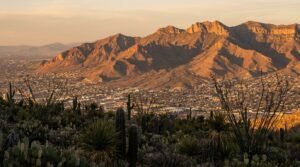
Crown Point Vista House sits 733 feet above the river on a stone promontory. Built in 1918, it’s an octagonal observatory with floor-to-ceiling windows. You can see 30 miles in both directions. Women’s Forum Viewpoint, one mile west, gives you the postcard shot of Vista House itself. Rowena Crest Viewpoint sits on the eastern end of the Gorge, where the landscape shifts from forest to high desert. The viewpoint overlooks the Tom McCall Preserve and the S-curves of the Historic Highway.
Planning Tip
The Gorge has 40-plus wineries, most clustered around Hood River. The region grows Pinot Noir, Syrah, and Riesling. Tastings run $15 to $25. Vineyards sit on both the Oregon and Washington sides. The climate here is drier than the Willamette Valley, with more sun and wind. You can hit three or four wineries in an afternoon without driving more than 20 miles.
For a scenic drive, take the Historic Columbia River Highway from Troutdale to Ainsworth State Park, 22 miles of curves, tunnels, and waterfall pullouts. I-84 runs parallel if you’re in a hurry, but you’ll miss the waterfalls. The full Gorge drive from Portland to The Dalles takes 90 minutes on the interstate, three hours if you stop at every viewpoint.
Where to Stay in the Columbia River Gorge
Hood River anchors the lodging scene. Most visitors base themselves here. The Columbia Gorge Hotel opened in 1921 and still operates as a luxury property. Spanish Colonial architecture. A 208-foot waterfall drops right behind the building. The restaurant serves Pacific Northwest cuisine with gorge views. Rooms run $200-$400 per night depending on season.
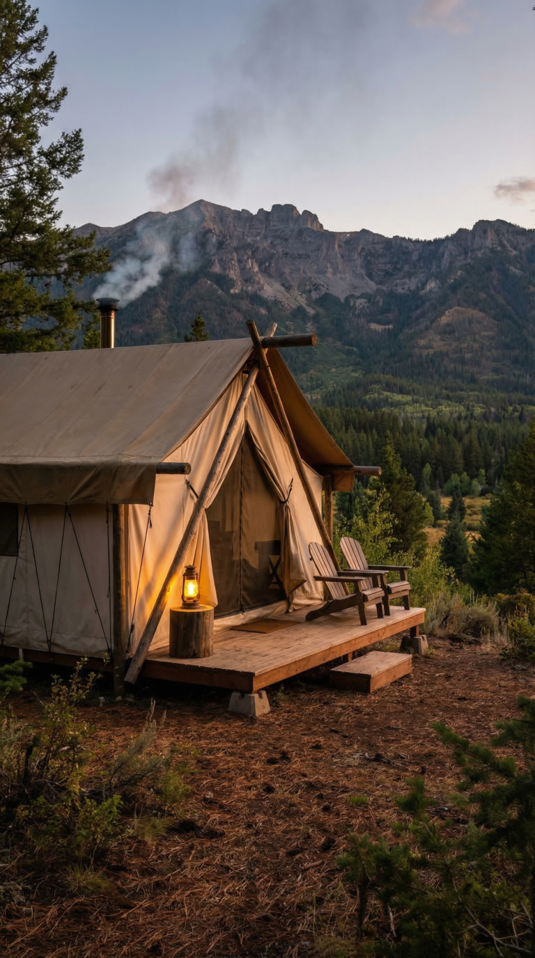
Under Canvas Columbia River Gorge sits 20 minutes from Hood River near Dee. Safari-style tents with real beds, wood-burning stoves, and private bathrooms. Mount Hood fills the view from your deck. Rates start around $250 per night. Open April through October only.
Cascade Locks offers cheaper motels and basic inns. Expect $80-$150 per night. You sacrifice charm but gain proximity to the central waterfall zone. Portland works as a base if you want city amenities. The western gorge sits 30-40 minutes east on I-84. More restaurant options. Better hotel variety.
Camping puts you closest to the trails. Eagle Creek Campground has 20 sites with vault toilets. No reservations. First-come basis. Ainsworth State Park runs $22 per night with fthick toilets and showers. Book through Oregon State Parks Campground Reservations. Viento State Park sits near Hood River with 58 sites and Columbia River access.
Book ahead for summer weekends. July and August fill up fast. Fall foliage season (late September through October) creates a second rush. Weekdays in spring offer the easiest availability.
Getting There & Getting Around
Portland sits 30 minutes west. That’s your gateway. Fly into Portland International Airport. Rent a car. Drive east on Interstate 84.
You need a car. Public transit barely exists here. The Columbia Gorge Express Schedule runs seasonally from Portland to a few trailheads, but it won’t get you everywhere. If you’re serious about exploring, you’re driving.
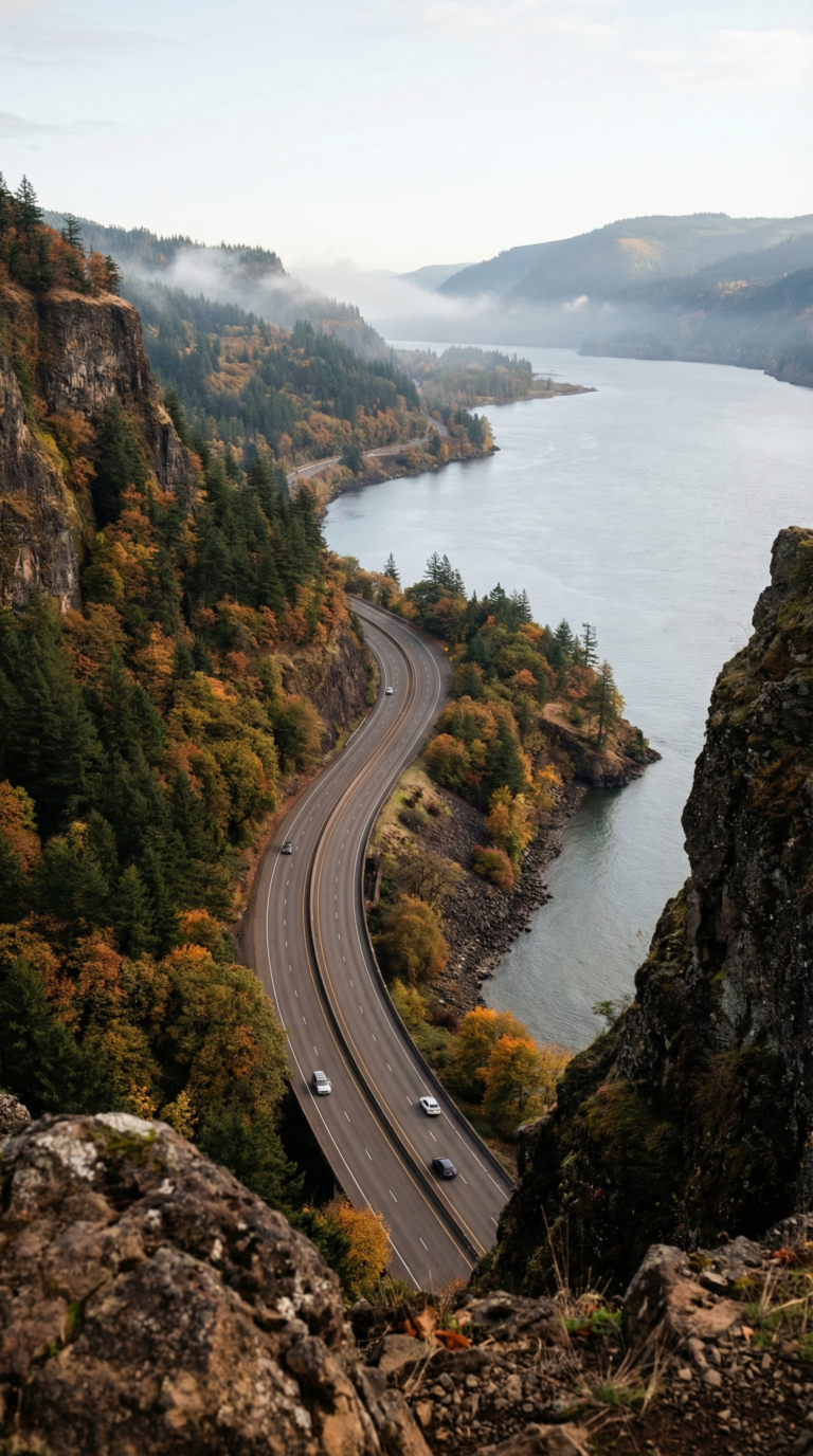
Two routes cut through the gorge. I-84 is the workhorse. Four lanes, year-round access, 75 miles from Troutdale to The Dalles. Fast. Boring. The Historic Columbia River Highway is the reason you came. Built in 1916, it hugs the cliffs, passes every major waterfall, and closes sections in winter when ice makes it undrivable. Check TripCheck Road Conditions before you go.
A Columbia River Gorge scenic drive takes two to three hours if you stop. You should stop. That’s the point. Budget a full day from Portland. Leave early. Multnomah Falls parking fills by 9 a.m. on weekends. The lot holds 200 cars. After that, you’re circling or driving to the next trailhead.
Weather shifts fast. Summer mornings start cool, afternoons hit 85°F. Winter brings ice storms that shut down the Historic Highway for weeks. Spring means rain. Always rain. Pack layers. Check road conditions the morning you drive.
Day Trips from the Columbia River Gorge
The Gorge sits within impressive distance of several major Oregon attractions. You can hit the road after breakfast and be back before dark.
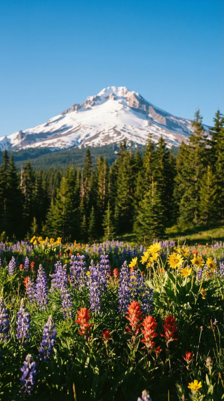
Mount Hood National Forest sprawls just 45 minutes south. Mount Hood National Forest wraps around Oregon’s highest peak at 11,249 feet. Timberline Lodge sits at 6,000 feet elevation, you can ski year-round on Palmer Glacier. The alpine meadows explode with wildflowers in July and August. Drive the 105-mile Mount Hood Scenic Byway for views of the volcano from every angle.
Portland lies a hour west on I-84. The city’s food cart pods serve everything with Thai curries and Venezuelan arepas for $8-12. Powell’s Books occupies an entire city block. Washington Park holds the Japanese Garden and International Rose Test Garden. Craft breweries cluster in the Southeast Division neighborhood. Street parking costs $2 per hour downtown.
Bagby Hot Springs sits two hours south in Mount Hood National Forest. You soak in hand-hewn cedar tubs fed by natural 136°F mineral water. The 1.5-mile trail from the parking lot crosses log bridges over Hot Springs Creek. Weekends get crowded, arrive before 10 AM or after 3 PM. Day use costs $5.
Silver Falls State Park runs 1.5 hours southwest near Silverton. The Trail of Ten Falls loops 7.2 miles past ten waterfalls between 27 and 177 feet tall. You walk behind South Falls and Lower South Falls on cave-like paths. The full loop takes 3-4 hours. Entry costs $5 per vehicle.
Cannon Beach stretches along the Pacific Coast two hours west. Haystack Rock rises 235 feet from the sand at low tide. Puffins nest on the rock from April through August. The town’s galleries and seafood restaurants line Hemlock Street. Check Travel Oregon for current tide tables before you go.
Willamette Valley wine country sits 1-1.5 hours southwest. Over 500 wineries produce Pinot Noir in the Dundee Hills and Eola-Amity Hills AVAs. Tasting room fees run $20-35 per person. Most wineries require reservations on weekends.
Practical Information for Visiting
Multnomah Falls requires timed-entry permits from May through September. Book on Recreation.gov. Slots fill fast on weekends. Some trails require a Northwest Forest Pass ($5 daily, $30 annual). Buy passes at trailheads or ranger stations.
Columbia River Gorge weather shifts fast. Winters run mild and wet, 40 to 50 degrees, rain most days October through April. Summers hit 75 to 85 degrees with almost no rain. Pack layers. Bring a rain jacket every month of the year. Temperatures drop 10 degrees in the shade of the forest. Sturdy hiking boots matter. Trails get muddy and slick.
Spring delivers waterfalls at peak flow. Snowmelt from the Cascades cranks up the volume. Summer brings crowds but clear trails. Fall colors peak mid-October through early November. Maples turn gold. Oaks go rust-red. Check the National Weather Service Portland forecast before you drive out.
The 2017 Eagle Creek Fire burned 50,000 acres. Many trails have reopened. Some remain closed. Check U.S. Forest Service trail conditions and closures before you hike. Conditions change after storms.
Cell service drops to nothing in parts of the Gorge. Download offline maps. Carry plenty of water, at least two liters per person. Stay on marked trails. Pack out all trash. Respect closure signs. They exist for a reason.
Best Time to Visit
The Columbia River Gorge has distinct seasons that affect accessibility and experience quality. Spring (March-May) offers peak waterfall flows from snowmelt, while summer (June-September) provides the best hiking conditions but requires permits for popular attractions. Winter brings dramatic ice formations but limits trail access due to wet, cold conditions.
Frequently Asked Questions
Is the Columbia River Gorge worth visiting?
Yes. The Gorge delivers 90+ waterfalls, serious hiking, and canyon views that punch above most Pacific Northwest destinations. Multnomah Falls alone pulls 2 million visitors a year, Oregon’s busiest natural site. You get easy waterfall walks for families, brutal climbs for hikers, wine tasting rooms, and photo ops at every turn. Portland sits 30, 40 minutes west. Day trips work. Weekend trips work better.
What state is the Columbia River Gorge in?
Both. The Columbia River forms the Oregon-Washington border through the Gorge. Oregon claims the south side. Washington takes the north. Most big-name waterfalls, Multnomah Falls, Latourell, Bridal Veil, sit on the Oregon side along the Historic Columbia River Highway. Washington has its own trails and viewpoints. The Columbia River Gorge National Scenic Area covers land in both states.
How long is the Columbia River Gorge scenic drive?
The Historic Columbia River Highway runs 75 miles from Troutdale to The Dalles. Drive it straight through and you’ll spend 2, 3 hours. Add waterfall stops and viewpoints and you’re looking at 4, 6 hours. The waterfall corridor from Troutdale to Cascade Locks is 40 miles. Budget 1.5, 2 hours for that section with stops. You can mix the Historic Highway with I-84 for a faster return loop.
Where does the Columbia River Gorge start and end?
The Gorge stretches 80 miles from the Sandy River near Troutdale to the Deschutes River near The Dalles. The western entrance is where the Columbia River slices through the Cascade Range. The eastern boundary hits the high desert plateau. The Columbia River Gorge National Scenic Area protects 292,500 acres along this stretch.
What is the most scenic part of the Columbia River Gorge?
The waterfall corridor between Troutdale and Cascade Locks wins. This 40-mile section packs Multnomah Falls, Latourell Falls, Bridal Veil Falls, and dozens more. Crown Point Vista House gives you the best wide shot of the Gorge. The Historic Columbia River Highway through here features stone bridges, tunnels, and cliff-hugging curves. It’s an engineering flex from the 1910s that still holds up.