Estimated reading time: 13 minutes
Last updated: 15 June 2026
Table of Contents
- Where Is the Cascade Range?
- Major Peaks, Volcanoes & Natural Attractions
- Getting There & Mountain Passes
- Weather & Best Time to Visit
- Frequently Asked Questions
Where Is the Cascade Range?
The Cascade Range is a 700-mile volcanic mountain chain extending from Lassen Peak in Northern California through Oregon and Washington to British Columbia, containing nearly 20 major active volcanoes.
How We Researched This Guide
We compiled this guide using national park service databases, regional tourism organizations, and firsthand reports from hikers and visitors. All trail conditions, fees, and seasonal information were verified as of writing, we recommend checking current park websites before heading out, as conditions can shift throughout the year.
Want to see the Cascade Range’s volcanic peaks up close? Watch our complete travel guide in 4K Ultra HD.
The Cascade Range ranks among North America’s most geologically active zones. Nearly 20 major volcanoes punctuate this chain. Mount St. Helens erupted in 1980, killing 57 people and blasting 1,300 feet off its summit. That explosion reminded everyone these peaks aren’t dormant relics.
The range runs 700 miles from Lassen Peak in Northern California through Oregon and Washington into British Columbia, according to the USGS Cascades Volcano Observatory. The NPS Cascade-Sierra Mountains Province data confirms 18 major volcanic peaks in the Cascade Arc, with at least seven erupting in the past 200 years.
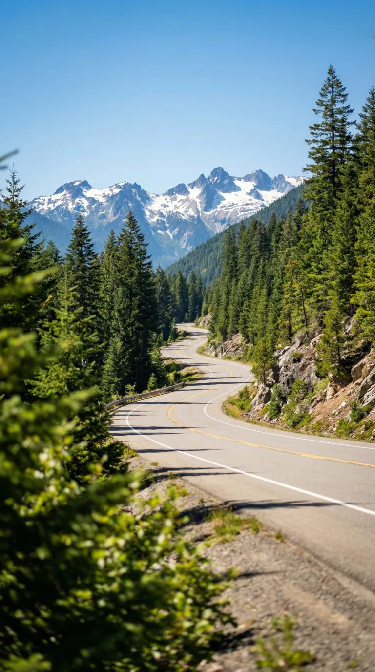
What sets the Cascades apart? Volcanic peaks like Mount Rainier, Mount Hood, and Mount Shasta tower over dense forests. Alpine lakes fill old calderas. Glaciers cling to north faces. Mountain passes like Snoqualmie and Stevens connect Seattle to eastern Washington. Trails range from easy waterfall walks to multi-day wilderness routes through lava fields.
This guide covers the major peaks and their volcanic history. You’ll find trail recommendations, mountain pass details, weather patterns by season, and answers to common visitor questions. No fluff. Just what you need to plan a trip.
Major Peaks, Volcanoes & Natural Attractions
The Cascade Range contains over 4,000 volcanic vents including Mount Rainier (14,411 feet, the highest peak), Mount St. Helens, and Mount Hood, plus clean alpine lakes like Diablo Lake and extensive wilderness hiking trails.
The Cascades sit directly on top of a tectonic collision zone. The Juan de Fuca plate slides beneath the North American plate here, creating the volcanic chain you see today. This subduction zone is part of the Pacific Ring of Fire. It’s been building mountains and triggering eruptions for millions of years.
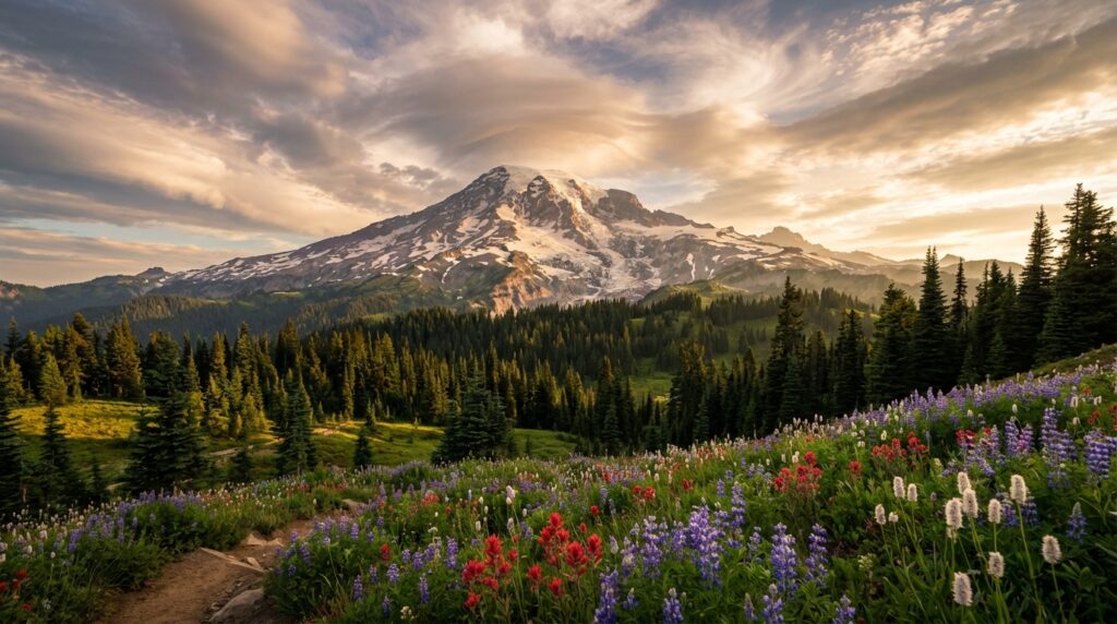
Nearly 20 major volcanoes punctuate the range. Mount Rainier dominates at 14,411 feet, the highest peak in the Cascades, according to USGS elevation data. Mount St. Helens blew its top in 1980, killing 57 people and flattening 230 square miles of forest. Mount Hood looms over Portland. Mount Shasta rises from California’s northern plains. Lassen Peak last erupted in 1917. Mount Baker and Glacier Peak guard the northern reaches in Washington.
The Mount Rainier National Park serves as the gem of the range. Glaciers carve the upper slopes. Wildflower meadows explode with color in July and August. Climbers attempt the summit year-round, though only about half reach the top. The park logged 1.67 million visitors in 2024.
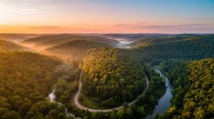
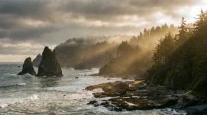
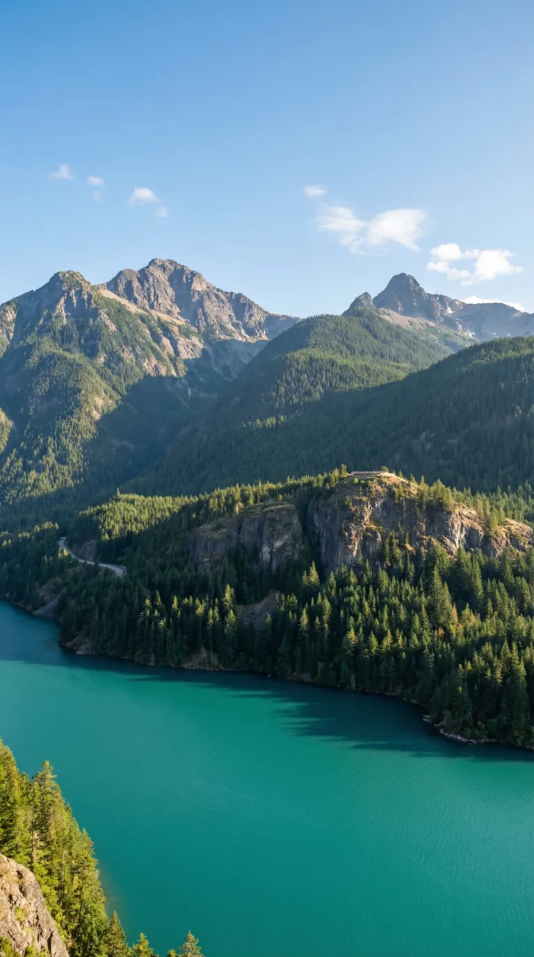
Diablo Lake sits in the North Cascades, glowing turquoise from glacial flour, rock dust ground by moving ice and suspended in the water. The color shifts depending on light and season. Ross Lake stretches 23 miles north into British Columbia, offering backcountry camping on floating platforms and kayak routes through old-growth forest. The Skagit Valley below these lakes hosts one of the largest winter bald eagle gatherings in the lower 48 states, up to 500 eagles arrive between December and February to feed on spawning salmon.
Hikers flock to the Cascade Pass trailhead. The 7.4-mile round trip climbs 1,800 feet to a col between jagged peaks. You’ll see Johannesburg Mountain, Mixup Peak, and the Ptarmigan Traverse. Glaciers hang on north-facing slopes. Marmots whistle from rockpiles. The trail opens in July most years, though snow lingers into August on the pass itself.
The Cascades Volcano Observatory tracks over 4,000 separate volcanic vents in the range. These include stratovolcanoes like Rainier, shield volcanoes, lava domes, and cinder cones. Some are millions of years old. Others formed within the last few centuries. The observatory monitors seismic activity, gas emissions, and ground deformation to predict future eruptions.
The major peaks line up from south to north like sentinels. Lassen Peak marks the southern end in California. Mount Shasta rises 14,179 feet, the second-highest Cascade volcano. Mount McLoughlin sits in southern Oregon. Crater Lake fills the collapsed caldera of Mount Mazama, which exploded 7,700 years ago. Mount Hood stands 11,240 feet tall, visible from downtown Portland. Mount Adams reaches 12,281 feet in southern Washington. Mount Rainier takes the crown at 14,411 feet. Glacier Peak hides in the wilderness at 10,541 feet. Mount Baker closes the lineup at 10,781 feet, just 30 miles from the Canadian border.
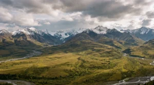
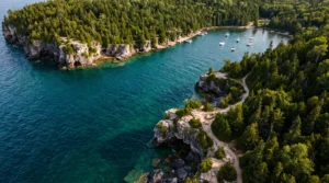
The North Cascades National Park protects 504,654 acres of the northern section. More than 300 glaciers cover the peaks here, more than any other U.S. national park outside Alaska. The park sees only 30,000 visitors per year, making it one of the least-visited major parks in the system. No roads cross the core wilderness. You hike in or you don’t see it.
These volcanoes aren’t dormant. They’re sleeping. Mount St. Helens proved that in 1980. Mount Rainier could erupt tomorrow or stay quiet for another thousand years. The subduction zone keeps grinding. Magma keeps rising. The Cascades keep growing.
Getting There & Mountain Passes
Major gateway cities to the Cascade Range include Seattle and Tacoma on the west side and Spokane on the east, with critical mountain passes like Snoqualmie, Stevens, White Pass, and Blewett Pass requiring WSDOT condition checks year-round.
Seattle sits 50 miles west of the Cascade crest. It’s the main jumping-off point for Snoqualmie Pass and the central Washington peaks. Tacoma provides quicker access to Mount Rainier National Park via Highway 410. Bellevue cuts 15 minutes off the drive to Snoqualmie if you’re coming from the Eastside suburbs. Bellingham is your gateway to the North Cascades and Mount Baker, it’s the last real city before the wilderness starts.
Spokane anchors the eastern side. You’ll use it to reach the dry pine forests and ski areas on the Cascade’s rain shadow slopes.
The mountain passes are the whole ballgame. Five major highways punch through the Washington Cascades. Snoqualmie Pass on Interstate 90 carries the most traffic, it’s the only year-round interstate route across the range. Elevation: 3,022 feet. Chains required November through April when conditions demand it. Stevens Pass on US Highway 2 sits higher at 4,061 feet. It closes more often than Snoqualmie during heavy snow. White Pass on US 12 reaches 4,500 feet and serves as the southern crossing in Washington. Blewett Pass on US 97 tops out at 4,102 feet, it’s the route to Leavenworth and the eastern slopes.
According to the Washington State Department of Transportation, these four passes receive an average of 400 to 450 inches of snow annually at their summits. That’s 33 to 37 feet. You need to check the Washington State Department of Transportation (WSDOT) mountain pass report before you drive. Conditions flip from clear to chain-required in 30 minutes during winter storms.
Oregon’s passes include Santiam Pass, Willamette Pass, and McKenzie Pass. McKenzie Pass closes completely from November through June, no exceptions. The Oregon Department of Transportation runs a similar system. Check the Oregon Department of Transportation (ODOT) TripCheck pass conditions before heading east from Eugene or Bend.
Pack chains between November and April even if the forecast looks clean. Mountain weather doesn’t care about your itinerary.
Weather & Best Time to Visit
Planning Tip
The Cascade Range experiences heavy winter snowfall (400-600 inches annually at higher elevations) with the best hiking weather from July through September when high-elevation trails are snow-free and temperatures range from 60-75°F.
The Cascades split the Pacific Northwest into two climate zones. Western slopes catch Pacific storms head-on, dumping 80 to 140 inches of rain annually. Eastern slopes sit in the rain shadow. They get maybe 20 inches. This isn’t subtle.
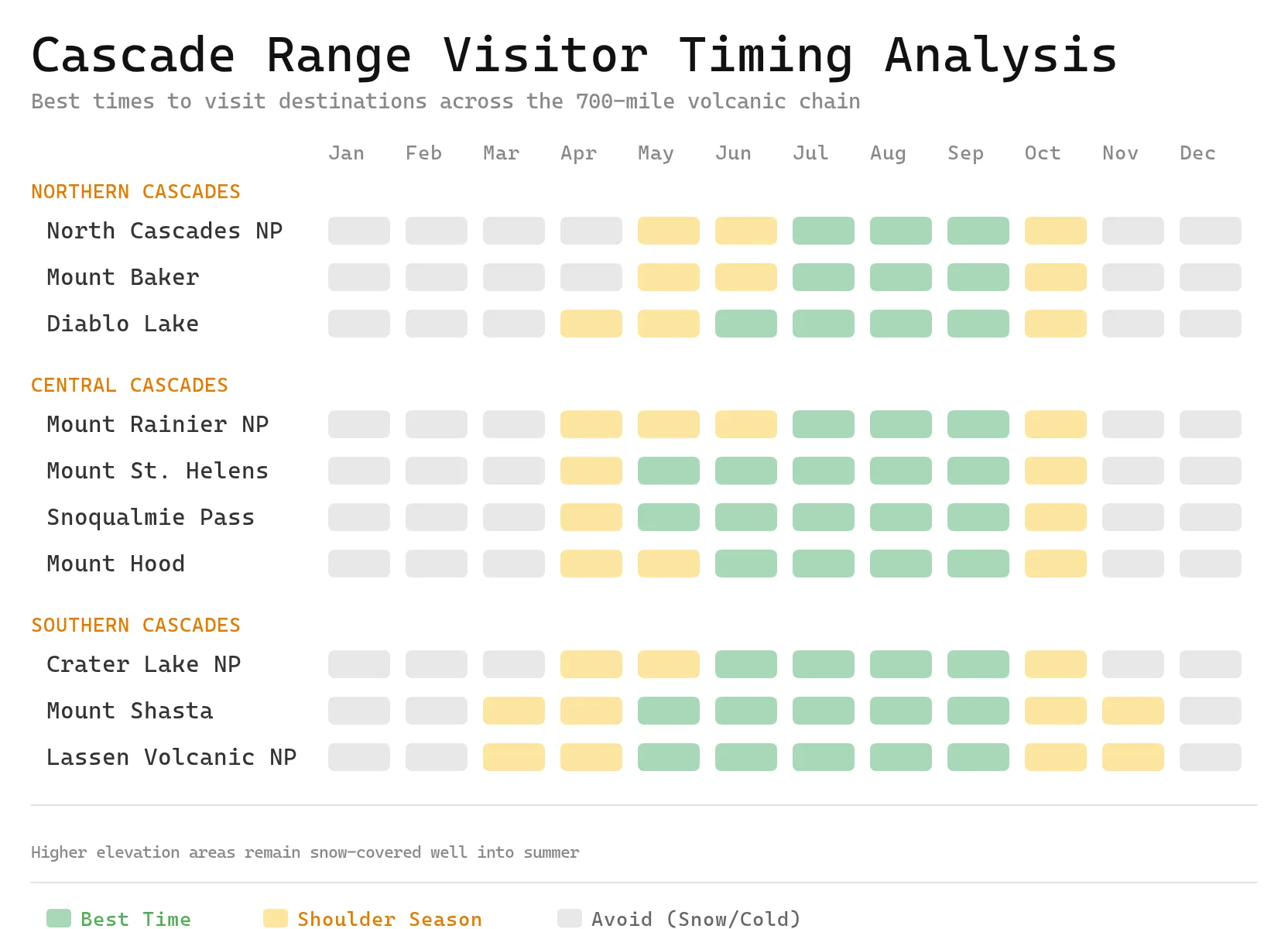
Winter hits hard from November through March. According to the National Weather Service, mountain passes record 400 to 600 inches of snow each season. That’s 33 to 50 feet. Highway crews close passes for days at a time. Avalanche danger runs high. Backcountry travel requires serious gear and training.
Spring brings false hope. April through June looks warm in the valleys, but snowpack lingers at elevation. Trails stay buried. Rivers swell with melt. Conditions shift fast. A sunny morning can turn into whiteout by noon.
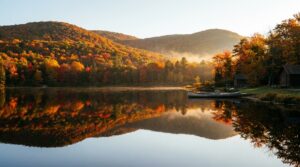
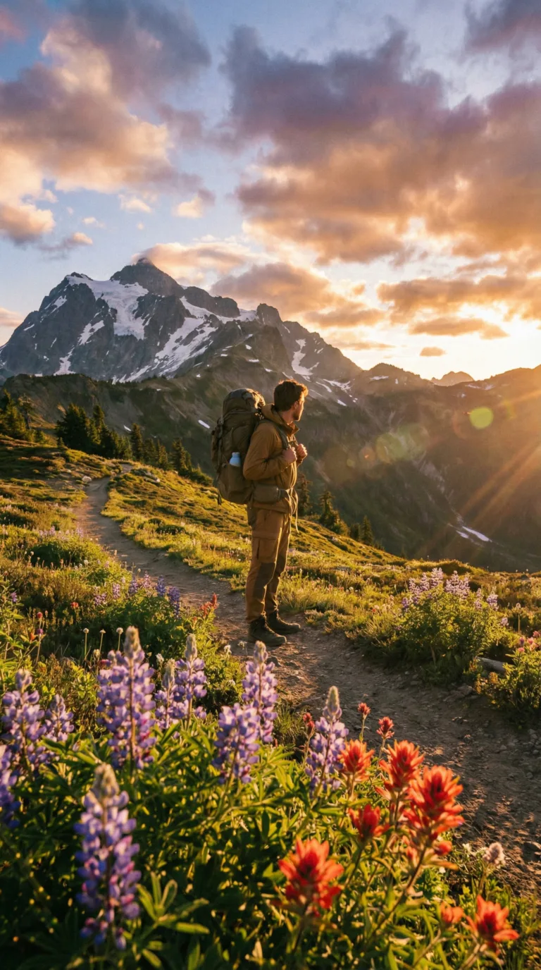
July through September is your window. High trails clear out. Wildflowers bloom across alpine meadows. Mid-elevation temperatures settle between 60 and 75 degrees. Storms still roll through, but they’re shorter and less violent. This is when most people visit. Trailhead parking lots fill by 8 a.m. on weekends.
October and November mark the transition. Snow returns to higher elevations. Weather becomes unpredictable. Some years you get crisp fall days with clear views. Other years, winter arrives in mid-October and doesn’t let go.
Check National Weather Service North Cascades Forecasts before every trip. Mountain weather changes in hours, not days. A forecast for Seattle means nothing 60 miles east at Snoqualmie Pass. Use pass-specific forecasts. The difference between 2,000 feet and 5,000 feet can be 30 degrees and six inches of snow.
The NOAA Volcano Hazards Program and USGS Cascade Range Volcano Updates monitor seismic activity across all major peaks. Eruptions are rare. The last significant event was Mount St. Helens in 1980. But the volcanoes remain active. Scientists track every tremor.
Pack layers no matter when you visit. Trailheads might be 70 degrees. Summits could be 35 with wind chill. Bring a rain shell even in August. Afternoon thunderstorms appear out of nowhere. Hypothermia kills people in summer, not just winter.
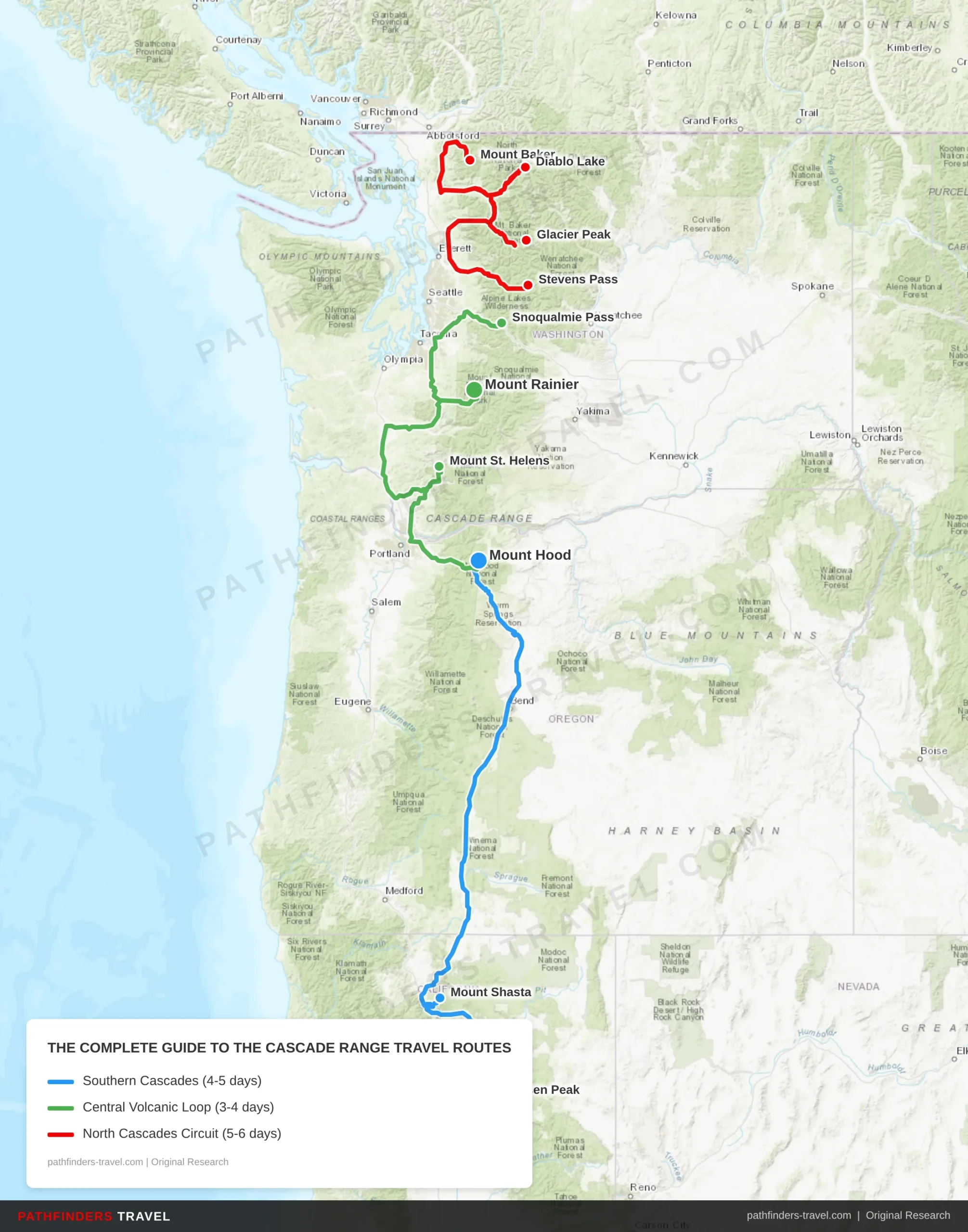
Travel Routes
The Complete Guide to the Cascade Range offers diverse travel experiences across multiple regions. Below are our recommended travel routes with key stops and estimated drive times.
| # | Stop | Highlights | Drive Time |
|---|---|---|---|
| 1 | Lassen Peak | Last erupted 1917, volcanic domes, Bumpass Hell thermal features | Start |
| 2 | Mount Shasta | 14,179 ft stratovolcano, climbing routes, Castle Lake | 1h 45m |
| 3 | Mount Hood | 11,249 ft peak, Timberline Lodge, year-round skiing | 4h 30m |
| # | Stop | Highlights | Drive Time |
|---|---|---|---|
| 1 | Mount Hood | Oregon’s highest peak, Timberline Trail, historic lodge | Start |
| 2 | Mount St. Helens | 1980 eruption site, Johnston Ridge Observatory, blast zone | 1h 15m |
| 3 | Mount Rainier | 14,411 ft highest Cascade peak, 26 glaciers, wildflower meadows | 2h |
| 4 | Snoqualmie Pass | I-90 mountain crossing, hiking trails, ski areas | 1h 30m |
| # | Stop | Highlights | Drive Time |
|---|---|---|---|
| 1 | Stevens Pass | Highway 2 crossing, Pacific Crest Trail, ski resort | Start |
| 2 | Diablo Lake | Turquoise glacial lake, boat tours, Ross Lake overlook | 2h |
| 3 | Mount Baker | 10,781 ft active volcano, extensive glacier system, climbing | 1h 45m |
| 4 | Glacier Peak | Remote 10,541 ft volcano, wilderness hiking, thermal springs | 3h |
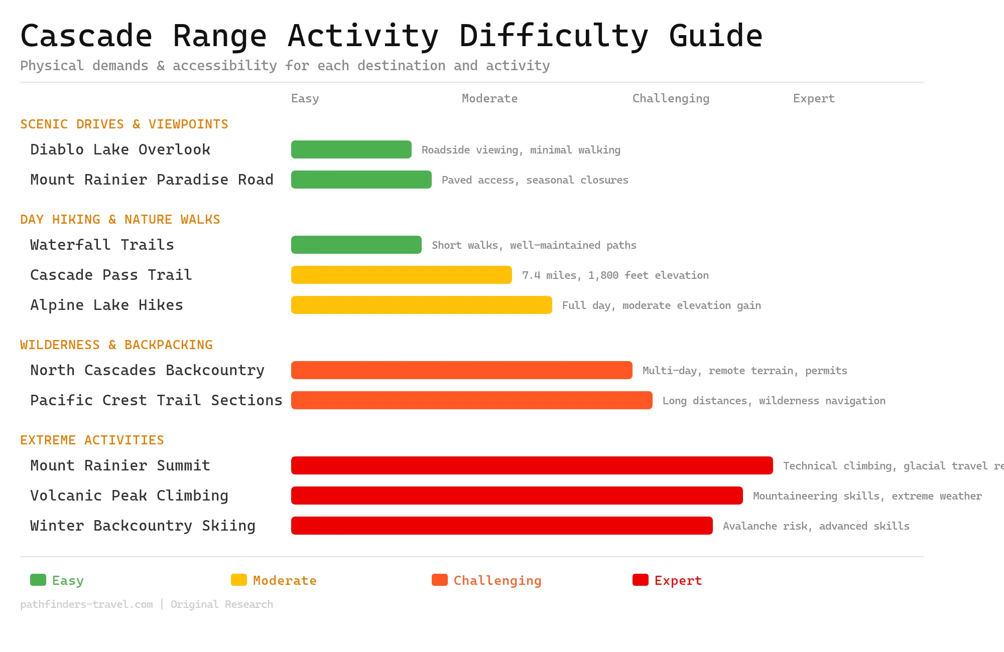
Activity Difficulty Guide
The Cascade Range offers activities spanning all difficulty levels, from roadside volcanic viewpoints to technical glacier climbing on 14,000-foot peaks. Most visitors enjoy moderate day hikes to alpine lakes and waterfalls, while experienced mountaineers tackle the region’s challenging volcanic summits.
Frequently Asked Questions
The Cascade Range extends 700 miles from Lassen Peak in Northern California to the confluence of the Nicola and Thompson rivers in British Columbia, containing nearly 20 major active volcanoes with the last major eruption occurring at Mount St. Helens in 1980.
Where does the Cascade Range start and end?
The Cascade Range runs from Lassen Peak (also called Mount Lassen) in northern California north through Oregon and Washington to the confluence of the Nicola and Thompson rivers in British Columbia, Canada. The range covers roughly 700 miles. It splits the wet Pacific coast from the drier inland zones. You cross the Cascades heading east, and the climate changes fast, rain forests give way to high desert within 50 miles.
How many volcanoes are in the Cascade Range?
The Cascade Arc holds nearly 20 major volcanoes spread across more than 4,000 separate volcanic vents. These include stratovolcanoes, shield volcanoes, lava domes, and cinder cones. Major active peaks include Mount Rainier, Mount St. Helens, Mount Hood, Mount Shasta, Mount Baker, Glacier Peak, and Lassen Peak. The USGS Cascade Volcano Observatory monitors all of them for seismic activity and gas emissions.
When was the last eruption in the Cascade Range?
The last major eruption happened at Mount St. Helens on May 18, 1980. The blast removed 1,300 feet from the summit and flattened 230 square miles of forest. Before that, Lassen Peak erupted from 1914 to 1921. Mount St. Helens had smaller eruptions between 2004 and 2008, building a new lava dome inside the crater. Several Cascade volcanoes still show geothermal activity, steam vents, hot springs, minor earthquakes. They’re not dormant. They’re sleeping.
What are the three tallest mountains in the Cascade Range?
Mount Rainier in Washington tops the list at 14,411 feet (4,392 meters). Mount Shasta in California comes second at 14,179 feet (4,322 meters). Mount Adams in Washington ranks third at 12,281 feet (3,743 meters). All three are active stratovolcanoes wrapped in glaciers. Climbers attempt all three year-round, though Rainier sees the most traffic, around 10,000 summit attempts annually.
Which US states does the Cascade Range run through?
In the United States, the Cascade Range runs through three states — Northern California, Oregon, and Washington — before continuing north into British Columbia, Canada. The most-visited stretch is in Washington and Oregon, home to Mount Rainier, Mount St. Helens, Mount Hood, and the North Cascades.