New Zealand offers a great journey through clean landscapes where ancient Maori culture blends with some of the world’s most impressive natural wonders. From Auckland’s urban skyline to Milford Sound’s dramatic fjords, this travel guide reveals the lesser-known spots and iconic destinations that make this island nation really extraordinary.
The unique evolution of this land, isolated for 85 million years, has created ecosystems and scenery found nowhere else on Earth.
Join me as this guide takes you through the most amazing places in New Zealand in beautiful 4K:
Auckland: Where Urban Meets Island Paradise
Auckland spreads across two beautiful harbors on New Zealand’s North Island, balancing city energy with natural splendor in a way that’s really unique. Nearly 2 million people call this region home, making it the country’s largest metropolitan area. What struck me most about Auckland was how the volcanic cones dot the landscape while sailboats fill the harbors, creating a beautiful visual contrast.
The Sky Tower dominates Auckland’s skyline, rising 328 meters above the city streets. This concrete needle serves as both a telecommunications hub and an observation deck, with glass elevators that climb the exterior in just 40 seconds. From the top, I could see Waiheke Island, a green highlight in the Hauraki Gulf just 35 minutes by ferry from downtown.
Waiheke Island spans 92 square kilometers and is home to about 9,000 permanent residents. Artists and winemakers have transformed this once quiet farming community into a cultural destination with rolling hills covered in vineyards meeting clean beaches along its shores.
Rotorua: Earth’s Raw Power on Display
This guide continued to Rotorua, a place where the earth really reveals its inner workings. This North Island city sits atop one of the world’s most active geothermal fields, with steam rising from sidewalk cracks and sulfur scenting the air. Here, the planet’s raw power shapes daily life in fascinating ways.
Planning Tip
Wai-O-Tapu thermal wonderland spreads across 18 square kilometers of volcanic terrain. The name means “sacred waters” in Maori, and these lands have drawn visitors for over 700 years. I was amazed by the mineral deposits that paint the landscape in impossible colors. The Champagne Pool bubbles at 74°C, its rim lined with bright orange antimony deposits.
Te Puia preserves both natural wonders and Maori culture within its grounds. The Pohutu geyser erupts here up to 20 times daily, shooting water 30 meters skyward as the southern hemisphere’s largest active geyser. These thermal zones remind us that our planet remains very much alive beneath our feet.
Taupo: Volcanic Forces and Turquoise Waters
Taupo sits beside New Zealand’s largest lake, born from an ancient eruption. The waters here tell stories of power and transformation, with nature’s raw energy still pulsing through this region today. The lake’s shores offer countless spots for quiet reflection, with small beaches dotting the coastline, each with its own character.
Local Maori consider these waters sacred, a living connection to their ancestors. The lake continues to shape life here, just as it has for thousands of years.
Huka Falls demonstrates what happens when a wide river suddenly narrows. The Waikato River squeezes through a rocky channel just 15 meters across, with 220,000 liters of water thundering over the edge every second. The turquoise color comes from air bubbles trapped in the churning flow. Standing on the viewing platform, I felt the ground vibrate beneath my feet.
Tongariro National Park: New Zealand’s Volcanic Heart
New Zealand’s volcanic heart beats strongest in Tongariro National Park. This sacred landscape spreads across the central North Island where three active volcanoes shape the terrain. Ancient Maori traditions blend with raw geological forces in a place that holds dual UNESCO status, recognized for both natural wonders and cultural significance.
The Tongariro Alpine Crossing cuts through this dramatic world like a pathway through time. This 19.4 km trail ranks among Earth’s most spectacular day hikes. I climbed from native forest into an alien landscape of volcanic craters and emerald lakes. The track crosses active volcanic terrain where steam vents remind visitors the earth remains very much alive.
Each section reveals different faces of this volcanic realm. The trail begins in gentle tussock lands before ascending the Devil’s Staircase. Beyond lies the Emerald Lakes, their brilliant green waters colored by dissolved minerals from the volcanic rock.
Wellington: The Windy Capital
Wellington spreads across the southern tip of New Zealand’s North Island, balancing government buildings with creative energy. Wind sweeps through the harbor, earning it the nickname “Windy Wellington.” The city’s compact center makes exploring on foot a natural choice.
Te Papa Museum is the nation’s storytelling heart. Its name means “our place” in Maori. Six floors hold treasures from across New Zealand’s history, with ancient Maori artifacts sharing space with contemporary art.
Mount Victoria Lookout rewards those who make the climb. At 196 meters above sea level, the summit opens to 360° views. From this height, Wellington’s geography becomes clear, hills cradle the city against the water’s edge. This lookout has watched over the city since Maori first settled these shores.
Picton and Queen Charlotte Sound
Picton is a small harbor town at the head of Queen Charlotte Sound. This gateway to the Marlborough Sounds sits where ferries arrive from the North Island. The town serves as both a destination and a starting point for exploring the intricate waterways beyond.
Ships have docked here since the 1850s when whalers first recognized the value of this sheltered port. The waterfront defines daily life in Picton. Morning light reveals fishing boats returning with their catch while pleasure craft prepare for the day ahead.
Queen Charlotte Sound extends from Picton like a vast network of flooded valleys. These waterways twist and turn for miles, creating hidden bays and secluded beaches. The sound formed thousands of years ago when rising seas filled ancient river valleys. Today, boats get around these same channels, following routes used by Maori travelers centuries before European arrival.
Abel Tasman National Park: Golden Beaches and Turquoise Waters
Abel Tasman National Park may be New Zealand’s smallest yet most visited national park. Golden beaches meet turquoise waters along this protected coastline, with native forest growing right to the sand’s edge. The park stretches across 87 square miles of pure coastal wilderness.
The Abel Tasman Coast Track winds through this destination for 37 miles. This Great Walk ranks among New Zealand’s most popular trails. The path follows the shoreline between Marahau and Wainui Bay, with hikers walking through native bush, across swing bridges, and along clean beaches.
Each section of the track reveals something new. Cleopatra’s Pool offers crystal-clear swimming beneath moss-covered rocks. Bark Bay’s tidal lagoon fills and empties with the rhythm of the sea. Split Apple Rock sits just offshore, its granite form split perfectly in half by nature. Seals bask on rocky outcrops while dolphins play in the deeper waters.
Punakaiki: The great Pancake Rocks
The Pancake Rocks in Punakaiki are the main attraction drawing visitors from around the world. These layered limestone formations look exactly like stacks of thick pancakes piled high. The rocks formed 30 million years ago when marine creatures and sediment compressed on the ocean floor. Time and pressure created these recognizable horizontal layers that seem almost too perfect to be natural.
Walking the coastal track, I witnessed the power of the blowholes between the rocks. During high tide, seawater rushes through vertical shafts carved by centuries of erosion. The water explodes upward in dramatic geysers, sometimes reaching 20 meters into the air. The combination of layered rock and surging ocean creates a display that changes with each wave.
Wanaka: Alpine Beauty on the Water’s Edge
Wanaka is a lakeside town where mountains rise straight from the water’s edge. This place sits quietly on the shores of its namesake lake, surrounded by peaks that pierce the Southern Alps. Here, nature shapes daily life in ways both subtle and profound.
Lake Wanaka stretches before visitors as New Zealand’s fourth-largest lake, covering 75 square miles. Its waters run deep and clear, reaching down 1,000 feet in places. The lake fills an ancient glacial valley carved when ice sheets covered this land 10,000 years ago. Today, those same waters reflect the surrounding mountains in perfect mirror images on calm mornings.
Roy’s Peak is the most recognizable summit in the region. The trail to its top climbs 5,177 feet through golden tussock grasslands. Each switchback reveals wider views until the entire lake system spreads below. From the summit, You’ll spot how glaciers sculpted this landscape, leaving behind a network of valleys and ridges that stretch to the horizon. The peak draws hikers from around the world, yet the experience remains deeply personal.
Queenstown: The Adventure Capital
Queenstown is the adventure capital of New Zealand’s South Island. This alpine resort town sits on the shores of a glacial lake surrounded by the dramatic peaks of the greats mountain range. Born from the 1860s gold rush, Queenstown has transformed into a year-round destination where nature’s beauty meets human ambition. The town pulses with energy, drawing visitors from across the globe.
Lake Wakatipu stretches before us like a giant’s mirror, its waters reflecting the surrounding mountains in perfect clarity. This S-shaped glacial lake runs for 80 kilometers through the heart of the region. Its waters reach depths of nearly 400 meters, making it New Zealand’s third-largest lake. The Maori believed a giant’s heart still beats at the bottom, causing the lake’s unusual rise and fall every few minutes.
The Skyline Gondola carries visitors 450 meters above Queenstown for views that stretch across the entire region. The steep climb takes just minutes, but the perspective shift feels profound. From Bob’s Peak Summit, You’ll spot Lake Wakatipu spreading below like a map of blue silk. The greats stand guard to the east while Cecil Peak dominates the western horizon. This vantage point reveals why filmmakers choose these landscapes for their most epic scenes.
Fiordland National Park: Where Mountains Meet Sea
In the southwest corner of New Zealand’s South Island, Fiordland National Park spreads across millions of acres of untouched wilderness. This is a land carved by ice and time, where mountains plunge straight into the sea. Ancient rainforests cling to steep valley walls. The park holds some of the planet’s most dramatic landscapes.
Milford Sound is the gem of Fiordland. Captain Cook sailed right past this narrow entrance twice, hidden as it was by the surrounding peaks. Sheer granite cliffs rise over 4,000 feet from dark waters. Waterfalls cascade down these walls, some dropping more than 500 feet in a single plunge. After heavy rain, hundreds of temporary falls appear, turning the sound into a living gallery of falling water.
The Milford Track winds through 33 miles of untouched wilderness. Known as “the finest walk in the world” since the 1800s, this trail reveals Fiordland’s hidden heart. Hikers pass through ancient beech forests where moss drapes every surface. The path crosses swing bridges over crystal-clear streams. Alpine meadows open up between the trees, offering views of snow-capped peaks.
Aoraki/Mount Cook National Park: New Zealand’s Alpine Heart
Aoraki/Mount Cook National Park is where New Zealand’s highest peaks pierce the sky. This alpine sanctuary spreads across the Southern Alps, home to glaciers, turquoise lakes, and mountain trails. Here, nature operates on a grand scale with Aoraki/Mount Cook itself rising 12,218 feet above sea level. The park covers 270 square miles of raw mountain wilderness.
The Hooker Valley Track offers one of the finest alpine walks in the country. This 6.2 mile trail leads through valleys carved by ancient ice, crossing swing bridges that span glacial streams. The path stays relatively flat, making it accessible while delivering spectacular views. Hikers pass beneath towering rock faces and alongside the milky waters of the Hooker River. The track ends at Hooker Lake where icebergs float in water colored by glacial flour.
Lake Pukaki stretches below the mountains like a sheet of turquoise glass. Fed by glacial melt from the Southern Alps, the lake gets its impressive blue color from rock particles suspended in the water. The lake runs 10 miles long and reaches depths of 230 feet. From its shores, Aoraki/Mount Cook dominates the northern horizon. On calm days, the mountain’s reflection doubles its presence in the still waters.
Lake Tekapo: Turquoise Waters and Starry Skies
Lake Tekapo stretches across the heart of New Zealand’s South Island like a massive turquoise gem. This glacial lake sits 700 meters above sea level, surrounded by the Southern Alps. The recognizable milky blue color comes from rock flour, tiny particles ground by glaciers and suspended in the water. Clear skies and minimal light pollution have made this region one of the world’s premier stargazing destinations.
The Church of the Good Shepherd stands alone on the lake’s edge. Built from local stone in 1935, this tiny chapel measures just 96 square meters yet draws visitors from across the globe. Its altar window frames a perfect view of the lake and mountains beyond. The church remains active, hosting services and weddings while serving as a memorial to the region’s early families.
When spring arrives between November and January, lupins transform the shoreline into ribbons of purple, pink, and blue. These tall wildflowers grow in dense clusters along the water’s edge and nearby riverbeds. Though introduced from North America, lupins have become part of Lake Tekapo’s seasonal identity. Photographers wait all year for these blooms, which create beautiful foregrounds against the turquoise water.
Kaikoura: Where Mountains Meet Pacific Ocean
Kaikoura is where the Pacific Ocean meets the Seaward Kaikoura Range. The name “Kaikoura” comes from the Maori words meaning “meal of crayfish.” The Kaikoura Peninsula Walkway traces the edge of this dramatic meeting point between land and sea. This clifftop path stretches for several miles along the peninsula’s rugged coastline.
Limestone formations have been carved by centuries of waves into platforms and pools. The track winds past these natural sculptures, offering views across the Pacific toward the horizon. Marine life thrives in the waters below the walkway. Fur seals rest on rocky outcrops, their dark forms visible against the pale stone.
During certain seasons, dolphins pass close to shore, their movements tracked by those walking the clifftops. The peninsula creates ocean currents that bring nutrients up from the deep, supporting this abundance of sea creatures. Walking this path means witnessing one of New Zealand’s richest marine environments from above.
The Coromandel Peninsula: Forest Meets Ocean
The Coromandel Peninsula stretches along New Zealand’s North Island like a rugged finger pointing into the Pacific. This land of ancient volcanic origins holds forests, beaches, and hidden coves within its boundaries. Here, the Hauraki Gulf meets the open ocean, creating a coastline that shifts between gentle bays and dramatic cliffs.
Cathedral Cove waits at the end of a coastal track near Hahei. The walk takes about 40 minutes through native bush before revealing this natural masterpiece. A massive archway carved by centuries of waves frames white sand and turquoise water. The limestone arch rises like a Gothic cathedral entrance, giving this beach its sacred name.
Hot Water Beach offers something found in few places on Earth. At low tide, thermal springs bubble up through the sand, creating natural hot pools. Visitors bring shovels to dig their own spa pools in the sand. The hot water mixes with cool ocean waves, creating a unique bathing experience controlled by the tides.
Much like New Zealand’s diverse landscapes, Australia offers equally stunning destinations, from Sydney’s iconic harbors to the otherworldly Blue Mountains.
If you’re drawn to dramatic landscapes shaped by ancient geological forces, you’ll also appreciate the Blue Mountains with their eucalyptus-covered valleys and towering sandstone cliffs.
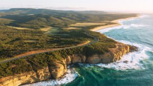
For another Pacific journey featuring coastal wonders and unique ecosystems, explore Australia’s Great Ocean Road with its limestone formations and pristine beaches.
New Zealand’s blend of culture and nature mirrors what you’ll find in Melbourne’s vibrant arts scene, where urban sophistication meets access to remarkable natural landscapes.
Cape Reinga: Where Two Oceans Meet
Cape Reinga is the northernmost accessible point of New Zealand’s North Island. This sacred headland rises where the Tasman Sea meets the Pacific Ocean in a constant dance of currents. The Cape Reinga Lighthouse is a solitary guardian on this remote promontory. Built in 1941, the white tower rises 10 meters above the clifftop, casting its beam 26 nautical miles into the darkness. The lighthouse replaced an earlier beacon from 1919, continuing a vital service for vessels navigating these turbulent waters.
From the lighthouse viewing platform, the meeting of two mighty oceans unfolds before visitors. This raw display of nature’s power reminds us why lighthouses remain essential even in our modern age. with glacial valleys and sunlight dancing across ancient forests, New Zealand stirs something deeper than just wanderlust.
You don’t simply cross its landscapes. You disappear into them. Caught somewhere between stillness and wonder, between time lost and time remembered. Whether tracing the windswept trails of the Milford track, drifting over the turquoise hush of Lake Tekapo, or stepping into the glowing hush of Waitomo’s hidden caverns, each place becomes part of you and your travel memories.